Back Castle Island (punta) CEB Castle Island (Massachusetts) German Castle Island (Massachusetts) French キャッスル・アイランド (マサチューセッツ州) Japanese Castle Island SIMPLE
| Castle Island | |
|---|---|
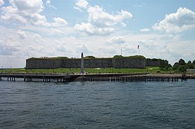
 Fort Independence at Castle Island | |
| Location | Boston, Suffolk, Massachusetts, United States |
| Coordinates | 42°20′15″N 71°00′38″W / 42.33750°N 71.01056°W[1] |
| Area | 22 acres (8.9 ha)[2] |
| Elevation | 33 ft (10 m)[1] |
| Established | Unspecified |
| Operator | Massachusetts Department of Conservation and Recreation |
| Website | Castle Island etc. |

Castle Island is a peninsula in South Boston on the shore of Boston Harbor. In 1928, Castle Island was connected to the mainland by a narrow strip of land and is thus no longer an island.[3] It has been the site of a fortification since 1634,[3] and is currently a 22-acre (8.9 ha) recreation site and the location of Fort Independence.[2]
- ^ a b "Castle Island". Geographic Names Information System. United States Geological Survey, United States Department of the Interior.
- ^ a b Cite error: The named reference
dcrwas invoked but never defined (see the help page). - ^ a b Cite error: The named reference
mhswas invoked but never defined (see the help page).


