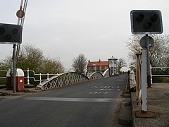
Cawood Bridge | |
|---|---|
 | |
| Coordinates | 53°50′01″N 1°07′42″W / 53.8337°N 1.1282°W |
| Carries | B1222 road |
| Crosses | River Ouse |
| Locale | Cawood, North Yorkshire |
| Heritage status | Grade II listed |
| Characteristics | |
| Design | Swing bridge |
| Total length | 295 feet (90 m) |
| History | |
| Opened | 31 July 1872 |
| Location | |
 | |
Cawood Bridge is a swing bridge which spans the Yorkshire River Ouse in North Yorkshire, England. Construction was authorised in 1870, with the formation of the Cawood Bridge bridge company.[1] It was opened on 31 July 1872 to replace the ferry, and is located about halfway between Naburn and Selby. It is the only bridge from the village of Cawood that crosses the river. It is Grade II listed.[2]
- ^ THE HOUSE OF LORDS SESSION 1870. Oxford University. 1870. p. 181.
- ^ Historic England. "Cawood Bridge (1316656)". National Heritage List for England. Retrieved 15 June 2015.
