Back جبال الألب الشرقية الوسطى Arabic Цэнтральныя Усходнія Альпы Byelorussian Цэнтральныя Ўсходнія Альпы BE-X-OLD Централни Източни Алпи Bulgarian Centrální krystalické Alpy Czech Centralalperne Danish Zentrale Ostalpen German Κεντρικές Ανατολικές Άλπεις Greek Centraj Orientaj Alpoj Esperanto Alpes Centrales Orientales Spanish
| Central Eastern Alps | |
|---|---|
 Venediger Group of the High Tauern | |
| Highest point | |
| Peak | Piz Bernina |
| Elevation | 4,049 m (13,284 ft) |
| Coordinates | 46°22′57″N 9°54′29″E / 46.38250°N 9.90806°E |
| Geography | |
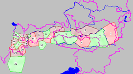
 Central Eastern Alps ranges (purple lines showing international borders and borders of Austrian states):
| |
| Countries | |
| States | |
| Parent range | Eastern Alps |
| Geology | |
| Orogeny | Alpine |
| Rock ages |
|
| Rock types | |
The Central Eastern Alps (German: Zentralalpen or Zentrale Ostalpen), also referred to as Austrian Central Alps (German: Österreichische Zentralalpen) or just Central Alps,[1] comprise the main chain of the Eastern Alps in Austria and the adjacent regions of Switzerland, Liechtenstein, Italy and Slovenia. South of them is the Southern Limestone Alps.
The term "Central Alps" is very common in the Geography of Austria as one of the seven major landscape regions of the country. "Central Eastern Alps" is usually used in connection with the Alpine Club classification of the Eastern Alps (Alpenvereinseinteilung, AVE). The Central Alps form the eastern part of the Alpine divide, its central chain of mountains, as well as those ranges that extend or accompany it to the north and south.
The highest mountain in the Austrian Central Alps is Grossglockner at 3,798 metres (12,461 ft).
- ^ Not to be confused with the other meaning of Central Alps i.e. the Swiss Alps.