Back شامولي Arabic شامولى ARZ चमोली जिला Bihari চামোলি জেলা Bengali/Bangla Districte de Chamoli Catalan Chamoli CEB Chamoli (Distrikt) German Distrito de Chamoli Spanish Chamoli barrutia Basque بخش چمولی Persian
This article needs additional citations for verification. (November 2020) |
Chamoli district | |
|---|---|
Clockwise from top-left: Badrinath Temple, Valley of Flowers National Park, Bedni Bugyal, Nanda Devi, Hemkund Sahib | |
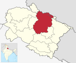
 Location in Uttarakhand | |
| Coordinates: 30°25′N 79°20′E / 30.42°N 79.33°E | |
| Country | |
| State | Uttarakhand |
| Division | Garhwal |
| Established | 24 February 1960 |
| Headquarters | Chamoli Gopeshwar |
| Tehsils | 12 |
| Government | |
| • District collector | Himanshu Khurana IAS[1] |
| • Lok Sabha constituency | Garhwal |
| • Vidhan Sabha constituencies | Badrinath, Karnaprayag, Tharali(SC) |
| Area | |
| • Total | 8,030 km2 (3,100 sq mi) |
| • Rank | I in the state |
| Highest elevation | 7,816 m (25,643 ft) |
| Lowest elevation (Gauchar) | 800 m (2,600 ft) |
| Population | |
| • Total | 391,605 |
| • Density | 49/km2 (130/sq mi) |
| Language | |
| • Official | Hindi[2] |
| • Regional | Garhwali[3] |
| Time zone | UTC+5:30 (IST) |
| Vehicle registration | UK 11 |
| Website | chamoli |
Chamoli district is a district of the Uttarakhand state of India.[4] It is bounded by the Tibet region to the north, and by the Uttarakhand districts of Pithoragarh and Bageshwar to the east, Almora to the south, Pauri Garhwal to the southwest, Rudraprayag to the west, and Uttarkashi to the northwest. The administrative headquarters of Chamoli district is in Gopeshwar.
Chamoli hosts a variety of destinations of pilgrim and tourist interest including Badrinath, Hemkund Sahib and Valley of Flowers. Chipko movement was first started in Chamoli.
- ^ "Collectorate | Chamoli District Website | India". Retrieved 29 July 2022.
- ^ "52nd REPORT OF THE COMMISSIONER FOR LINGUISTIC MINORITIES IN INDIA" (PDF). nclm.nic.in. Ministry of Minority Affairs. Archived from the original (PDF) on 25 May 2017. Retrieved 9 October 2019.
- ^ "Garhwali". Ethnologue. Retrieved 24 February 2021.
- ^ "Chamoli district at a glance" (PDF).


