Back مقاطعة شافيز (نيومكسيكو) Arabic Chaves County, New Mexico BAR Чавес Bulgarian চাভেস কাউন্টি, নিউ মেক্সিকো BPY Chaves Gông (New Mexico) CDO Чавес (гуо, Нью-Мексико) CE Chaves County CEB Chaves County, Mecsico Newydd Welsh Chaves County German Condado de Chaves Spanish
Chaves County | |
|---|---|
 Chaves County Courthouse in Roswell | |
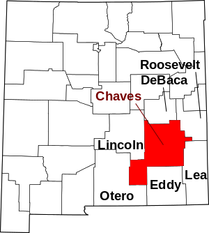
 Location within the U.S. state of New Mexico | |
 New Mexico's location within the U.S. | |
| Coordinates: 33°22′N 104°28′W / 33.36°N 104.47°W | |
| Country | |
| State | |
| Founded | February 25, 1889 |
| Named for | José Francisco Chaves |
| Seat | Roswell |
| Largest city | Roswell |
| Area | |
| • Total | 6,075 sq mi (15,730 km2) |
| • Land | 6,065 sq mi (15,710 km2) |
| • Water | 9.8 sq mi (25 km2) 0.2% |
| Population (2020) | |
| • Total | 65,157 |
| • Density | 11/sq mi (4/km2) |
| Time zone | UTC−7 (Mountain) |
| • Summer (DST) | UTC−6 (MDT) |
| Congressional districts | 1st, 2nd, 3rd |
| Website | co |
Chaves County is a county in New Mexico, United States. As of the 2020 census, the population was 65,157.[1] Its county seat is Roswell.[2] Chaves County was named for Colonel Jose Francisco Chaves, a military leader there during the Civil War and later in Navajo campaigns. The county was created by the New Mexico Territorial Legislature on February 25, 1889, out of land from Lincoln County.
Chaves County comprises the Roswell, New Mexico Micropolitan Statistical Area.
- ^ "Chaves County, New Mexico". United States Census Bureau. Retrieved July 1, 2023.
- ^ "Find a County". National Association of Counties. Archived from the original on May 31, 2011. Retrieved June 7, 2011.
