Back مقاطعة شايان (كانساس) Arabic Cheyenne County, Kansas BAR Шайен (окръг, Канзас) Bulgarian চেয়ান্নে কাউন্টি, ক্যানসাস BPY Cheyenne Gông (Kansas) CDO Шайенн (гуо, Канзас) CE Cheyenne County (kondado sa Tinipong Bansa, Kansas) CEB Cheyenne County (Kansas) Czech Cheyenne County, Kansas Welsh Cheyenne County (Kansas) German
Cheyenne County | |
|---|---|
 Cheyenne County Courthouse in St. Francis (2010) | |
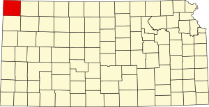
 Location within the U.S. state of Kansas | |
 Kansas's location within the U.S. | |
| Coordinates: 39°48′N 101°48′W / 39.800°N 101.800°W | |
| Country | |
| State | |
| Founded | March 20, 1873 |
| Named for | Cheyenne tribe[1] |
| Seat | St. Francis |
| Largest city | St. Francis |
| Area | |
| • Total | 1,021 sq mi (2,640 km2) |
| • Land | 1,020 sq mi (2,600 km2) |
| • Water | 1.1 sq mi (3 km2) 0.1% |
| Population | |
| • Total | 2,616 |
| • Density | 2.6/sq mi (1.0/km2) |
| Time zone | UTC−6 (Central) |
| • Summer (DST) | UTC−5 (CDT) |
| Area code | 785 |
| Congressional district | 1st |
| Website | cncoks.us |
Cheyenne County is a county located in the northwest corner of the U.S. state of Kansas. Its county seat and most populous city is St. Francis.[3] As of the 2020 census, the county population was 2,616.[2] The county was named after the Cheyenne tribe.[1]
- ^ a b Blackmar 1912a, p. 327.
- ^ a b "QuickFacts; Cheyenne County, Kansas; Population, Census, 2020 & 2010". United States Census Bureau. Archived from the original on August 15, 2021. Retrieved August 15, 2021.
- ^ "Find a County". National Association of Counties. Archived from the original on May 9, 2015. Retrieved June 7, 2011.