Back Tempestade na Costa Leste Americana em 1994 Portuguese Christmas 1994 nor'easter SIMPLE 1994年圣诞节东北风暴 Chinese
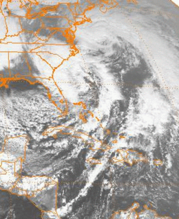
 Visible image of the pair of cyclones interacting near the Eastern Seaboard from 1 p.m. EST (08:00 UTC) on December 23, 1994 | |
| Type | Nor'easter |
|---|---|
| Formed | December 22, 1994 |
| Dissipated | December 26, 1994 |
| Lowest pressure | 970 mbar (hPa) |
| Maximum snowfall or ice accretion | No snow or ice reported |
| Fatalities | 2 |
| Damage | > $21 million 1994 USD |
| Areas affected | East Coast of the United States |
The Christmas 1994 nor'easter was an intense cyclone along the East Coast of the United States and Atlantic Canada. It developed from an area of low pressure in the southeast Gulf of Mexico near the Florida Keys, and moved across the state of Florida. As it entered the warm waters of the Gulf Stream in the Atlantic Ocean, it began to rapidly intensify, exhibiting traits of a tropical system, including the formation of an eye. It attained a pressure of 970 millibars on December 23 and 24, and after moving northward, it came ashore near New York City on Christmas Eve. Because of the uncertain nature of the storm, the National Hurricane Center (NHC) did not classify it as a tropical cyclone.
Heavy rain from the developing storm contributed to significant flooding in South Carolina. Much of the rest of the East Coast was affected by high winds, coastal flooding, and beach erosion. New York State and New England bore the brunt of the storm; damage was extensive on Long Island, and in Connecticut, 130,000 households lost electric power during the storm. Widespread damage and power outages also occurred throughout Rhode Island and Massachusetts, where the storm generated 30-foot (9.1 m) waves along the coast. Because of the warm weather pattern that contributed to the storm's development, precipitation was limited to rain. Two people were killed, and damage amounted to at least $21 million.