Back جيشن سيليزيا Arabic Цешынская Сілезія Byelorussian Цешынская Сылезія BE-X-OLD Тешинска Силезия Bulgarian Těšínsko Czech Teschener Schlesien German Σιλεσία του Τσιέσιν Greek Teŝinio Esperanto Silesia de Cieszyn Spanish Silésie de Cieszyn French
Cieszyn Silesia
Těšín Silesia | |
|---|---|
| |
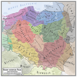
 Location of Cieszyn Silesia on the map of Poland | |
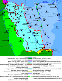
 Polish map of Cieszyn Silesia. The solid black line is the historical border of the region, and the broken black line is the international border. | |
| Coordinates: 49°44′56″N 18°37′34″E / 49.749°N 18.626°E | |
| Country | |
| Historical region | Upper Silesia |
| Seat | Cieszyn |
| Area | |
| • Total | 2,280 km2 (880 sq mi) |
| Population | |
| • Total | 810,000 |
| • Density | 360/km2 (920/sq mi) |
| Time zone | UTC+1 (CET) |
| • Summer (DST) | UTC+2 (CEST) |


Cieszyn Silesia, Těšín Silesia or Teschen Silesia (Polish: Śląsk Cieszyński [ˈɕlɔ̃sk tɕɛˈʂɨj̃skʲi] ; Czech: Těšínské Slezsko [ˈcɛʃiːnskɛː ˈslɛsko] or Těšínsko [ˈcɛʃiːnsko] ; German: Teschener Schlesien or Olsagebiet) is a historical region in south-eastern Silesia, centered on the towns of Cieszyn and Český Těšín and bisected by the Olza River. Since 1920 it has been divided between Poland and Czechoslovakia, and later the Czech Republic. It covers an area of about 2,280 square kilometres (880 sq mi) and has about 810,000 inhabitants, of which 1,002 square kilometres (387 sq mi) (44%) is in Poland, while 1,280 square kilometres (494 sq mi) (56%) is in the Czech Republic.
The historical boundaries of the region are roughly the same as those of the former independent Duchy of Cieszyn. Currently, over half of Cieszyn Silesia forms one of the euroregions, the Cieszyn Silesia Euroregion, with the rest of it belonging to Euroregion Beskydy.[1][2]
- ^ "Euroregion Ślask Cieszyński – Těšínské Slezsko W PIGUŁCE" (PDF) (in Polish). pp. 4–5.
- ^ "Euroregion Těšínské Slezsko. Seznam obcí tvořících euroregion v roce 2004" (in Czech).


