Back مقاطعة كلالام (واشنطن) Arabic مقاطعة كلالام، واشينطون ARZ Clallam County, Washington BAR Клалам (окръг) Bulgarian ক্লাললাম কাউন্টি, ৱাশিংটন BPY Clallam Gông (Washington) CDO Клаллам (гуо, Вашингтон) CE Clallam County CEB Clallam County Czech Clallam County, Washington Welsh
Clallam County | |
|---|---|
 | |
 Location within the U.S. state of Washington | |
 Washington's location within the U.S. | |
| Coordinates: 48°06′39″N 123°53′23″W / 48.11083°N 123.88972°W | |
| Country | |
| State | |
| Founded | April 26, 1854 |
| Seat | Port Angeles |
| Largest city | Port Angeles |
| Area | |
| • Total | 2,671 sq mi (6,920 km2) |
| • Land | 1,738 sq mi (4,500 km2) |
| • Water | 932 sq mi (2,410 km2) 35% |
| Population (2020) | |
| • Total | 77,155 |
| • Estimate (2023) | 77,616 |
| • Density | 44.4/sq mi (17.1/km2) |
| Time zone | UTC−8 (Pacific) |
| • Summer (DST) | UTC−7 (PDT) |
| Congressional district | 6th |
| Website | clallamcountywa.gov |
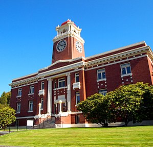
Clallam County is a county in the U.S. state of Washington. As of the 2020 census, the population was 77,155,[1] with an estimated population of 77,616 in 2023. The county seat and largest city is Port Angeles; the county as a whole comprises the Port Angeles, WA Micropolitan Statistical Area.[2] The name is a Klallam word for "the strong people". The county was formed on April 26, 1854.[3] Located on the Olympic Peninsula, it is south from the Strait of Juan de Fuca, which forms the Canada–US border, as British Columbia's Vancouver Island is across the strait.
Clallam County was a bellwether, voting for the winning candidate in every presidential election from 1980 to 2020, holding the longest record for predicting official presidential election winners in the entire country.[4] It has also voted the winning candidate in every election since 1920 except for 1968, 1976, and 2024.[5][6]
- ^ "State & County QuickFacts". United States Census Bureau. Retrieved November 10, 2024.
- ^ "Find a County". National Association of Counties. Archived from the original on May 31, 2011. Retrieved June 7, 2011.
- ^ "Milestones for Washington State History — Part 2: 1851 to 1900". HistoryLink.org. March 6, 2003.
- ^ "What does Clallam County know? Voters just chose a winner for the tenth straight election". kitsapsun.com. Retrieved November 8, 2020.
- ^ "Clallam County continues its streak of picking every presidential winner since 1980". king5.com. Retrieved November 8, 2020.
- ^ Smith, Helen (November 6, 2024). "Clallam County voted for losing presidential candidate for first time in 40 years". KING-TV.

