Back Cochabamba Afrikaans كوتشابامبا Arabic كوتشابامبا ARZ Quchapampa Aymara Koçabamba Azerbaijani Качабамба Byelorussian Качабамба BE-X-OLD Кочабамба Bulgarian ཀོ་ཅ་བང་ལྦ་ Tibetan Cochabamba Catalan
This article needs additional citations for verification. (January 2009) |
Cochabamba
Quchapampa | |
|---|---|
City & Municipality | |
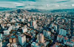
From the top to bottom, left to right: Metropolitan Cathedral, Palacio Portales, Templo del Hospicio, Aerial view of central Cochabamba, Tunari mountains, Banco Mercantil Simon Patiño, Cochabamba seat of government | |
| Nicknames: "City of Eternal Spring" "The Garden City" "La Llajta" | |
| Coordinates: 17°23′18″S 66°09′35″W / 17.38833°S 66.15972°W | |
| Country | |
| Department | Cochabamba |
| Province | Cercado Province |
| Municipality | Cochabamba Municipality |
| Founded | August 15, 1571 |
| Government | |
| • Type | Municipal Autonomous Government |
| • Mayor | Manfred Reyes Villa (Súmate) |
| Area | |
| • City & Municipality | 170 km2 (70 sq mi) |
| • Land | 169 km2 (65 sq mi) |
| • Water | 1 km2 (0.4 sq mi) |
| • Urban | 111 km2 (43 sq mi) |
| Elevation | 2,558 m (8,392 ft) |
| Population (2012 Census)[1] | |
| • Urban | 856,198 |
| • Metro | 1,430,688 |
| Demonym | Cochabambino |
| GDP (PPP, constant 2015 values) | |
| • Year | 2023 |
| • Total (Metro) | $11.8 billion[2] |
| • Per capita | $8,400 |
| Time zone | UTC-4 (BOT) |
| Climate | BSk |
| Website | Official website |
Cochabamba (Aymara: Quchapampa; Quechua: Quchapampa) is a city and municipality in central Bolivia in a valley in the Andes mountain range. It is the capital of the Cochabamba Department and the fourth largest city in Bolivia, with a population of 630,587 according to the 2012 Bolivian census.[1] Its name is from a compound of the Quechua words qucha "lake" and pampa, "open plain."[3] Residents of the city and the surrounding areas are commonly referred to as cochalas or, more formally, cochabambinos.
It is known as the "City of Eternal Spring" or "The Garden City" because of its spring-like temperatures all year round.[4] It is also known as "La Llajta," which means "town" in Quechua. It is the largest urban center between the higher capital of La Paz and Santa Cruz de la Sierra in the tropical plains of the east. It sits south-west of the Tunari mountains, and north of the foothills of the Valle Alto. In antiquity, the area featured numerous lakes, which gave the city its name. Many of these lakes have since disappeared to urban development, but Coña Coña and Alalay lakes are extant examples. It has been a populated settlement since the Pre-Inca period, and is today an important cultural, educational, political, and commercial centre.
- ^ a b "Ciudades/Comunidades/Centros poblados y Localidades Empadronadas en el Censo de Población y Vivienda 2012". Instituto Nacional de Estadística de Bolivia. Archived from the original on 2015-06-12. Retrieved 2015-06-10.
- ^ "TelluBase—Bolivia Fact Sheet (Tellusant Public Service Series)" (PDF). Tellusant. Retrieved 2024-01-11.
- ^ Diccionario Bilingüe Iskay simipi yuyayk'ancha pdf[page needed]
- ^ Pisarro, Marcelo (14 January 2021). "Veredas cochabambinas". cienciaspardas.substack.com. Retrieved 2021-03-17.


