Back Cockburn Island French コックバーン島 (カナダ) Japanese Cockburn Island Polish Cockburn Island, Ontario SIMPLE
Cockburn Island | |
|---|---|
| Township of Cockburn Island | |
 Aerial view of Cockburn Island | |
| Coordinates: 45°55′14″N 83°22′25″W / 45.92056°N 83.37361°W[1] | |
| Country | Canada |
| Province | Ontario |
| Region | Northeastern Ontario |
| District | Manitoulin |
| Settled | ca. 1880 |
| Government | |
| • Reeve | Brenda Jones |
| • Federal riding | Algoma—Manitoulin—Kapuskasing |
| • Prov. riding | Algoma—Manitoulin |
| Area | |
| • Land | 171.04 km2 (66.04 sq mi) |
| Population (2021)[2] | |
• Total | 16 |
| • Density | 0/km2 (0/sq mi) |
| Time zone | UTC-5 (EST) |
| • Summer (DST) | UTC-4 (EDT) |
| Postal Code FSA | P0P |
| Area code(s) | 705, 249 |

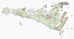
Cockburn Island is an island and township municipality in the Canadian province of Ontario, located in the Manitoulin District.[1] It is separated from the westernmost point of Manitoulin Island by the Mississagi Strait, and from Michigan's Drummond Island by the False Detour Channel. The island is incorporated as and coterminous with the municipal Township of Cockburn Island.[3][4]
The island contains approximately 90 cottages that are owned and occupied by families as vacation properties, and thus has an estimated population of 200 to 300 people in the summer;[5] however, the island's sole permanent year-round resident is a maintenance employee of the township,[6] and thus its official census population has sometimes been recorded as zero due to Statistics Canada practices of rounding off the populations of communities smaller than 15 people.[7] Historically, however, the island had a permanent resident population of up to 1,000 people, and evolved from a conventionally populated settlement into a seasonal cottage country area after the island's regular ferry service was discontinued in the 1960s.[6]
- ^ a b "Cockburn Island". Geographical Names Data Base. Natural Resources Canada. Retrieved 2020-10-15.
- ^ a b Cite error: The named reference
cp2016was invoked but never defined (see the help page). - ^ "Toporama (on-line map and search)". Atlas of Canada. Natural Resources Canada. 12 September 2016. Retrieved 2020-10-15.
- ^ "Ontario Geonames GIS (on-line map and search)". Ontario Ministry of Natural Resources and Forestry. 2014. Retrieved 2020-10-15.
- ^ "Municipalities wait for the other shoe to drop". Toronto Star, February 1, 1997.
- ^ a b "History of Cockburn Island: Part 3". North Channel Current, October 3, 2014.
- ^ Conor Mihell, "The Island That Time Forgot: Not every thriving cottage community can claim a population of zero. But then, Cockburn Island isn't your average cottage community". Cottage Life, June 2013.

