Back Coconino National Forest CEB Coconino National Forest German جنگل ملی کوکونینو Persian Forêt nationale de Coconino French Foresta nazionale di Coconino Italian 科科尼诺国家森林 Chinese
| Coconino National Forest | |
|---|---|
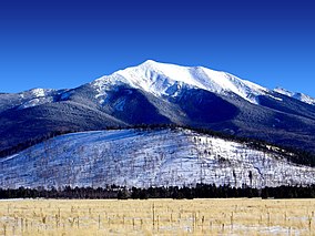
 San Francisco Peaks, winter | |
| Location | Coconino, Yavapai, and Gila counties, Arizona, US |
| Nearest city | Flagstaff, Arizona |
| Coordinates | 34°45′27″N 111°45′52″W / 34.75750°N 111.76444°W |
| Area | 1,856,038 acres (7,511.12 km2) |
| Established | July 2, 1908 |
| Visitors | roughly 1,890,000 (in 2004) |
| Governing body | U.S. Forest Service |
| Website | www.fs.usda.gov/coconino |
 | |
The Coconino National Forest is a 1.856-million acre (751,000 ha) United States National Forest located in northern Arizona in the vicinity of Flagstaff, with elevations ranging from 2,600 feet to the highest point in Arizona at 12,633 feet (Humphrey's Peak). Originally established in 1898 as the "San Francisco Mountains National Forest Reserve", the area was designated a U.S. National Forest by Pres. Theodore Roosevelt on July 2, 1908, when the San Francisco Mountains National Forest Reserve was merged with lands from other surrounding forest reserves to create the Coconino National Forest.[1] Today, the Coconino National Forest contains diverse landscapes, including deserts, ponderosa pine forests, flatlands, mesas, alpine tundra, and ancient volcanic peaks. The forest surrounds the towns of Sedona and Flagstaff and borders four other national forests; the Kaibab National Forest to the west and northwest, the Prescott National Forest to the southwest, the Tonto National Forest to the south, and the Apache-Sitgreaves National Forest to the southeast. The forest contains all or parts of nine designated wilderness areas, including the Kachina Peaks Wilderness, which includes the summit of the San Francisco Peaks.[2] The headquarters are in Flagstaff. The Coconino National Forest consists of three districts: Flagstaff Ranger District, Mogollon Rim Ranger District, and Red Rock Ranger District, which have local ranger district offices in Flagstaff, Happy Jack, and Sedona.[3]
- ^ "Historical Establishment Dates Pertaining to the Coconino National Forest". U.S. Forest Service, Coconino National Forest. Archived from the original on 2011-11-11. Retrieved 2006-08-13.
- ^ "About Us: Statistics". U.S. Forest Service, Coconino National Forest. Archived from the original on 2006-09-01. Retrieved 2006-08-13.
- ^ "USFS Ranger Districts by State" (PDF). Archived from the original (PDF) on 2012-01-19. Retrieved 2009-05-16.

