Back Катангскі чаравік Byelorussian Botte du Katanga French Peduncolo del Congo Italian Pedículo do Congo Portuguese Катангский ботинок Russian Катанзька віднога Ukrainian

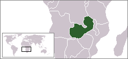
The Congo Pedicle (at one time referred to as the Zaire Pedicle; in French la botte du Katanga, meaning 'Katanga boot') is the southeast salient of the Haut-Katanga Province of the Democratic Republic of the Congo, which divides neighbouring Zambia into two lobes. In area, the pedicle is similar in size to Wales or New Jersey. 'Pedicle' is used in the sense of 'a little foot'. 'Congo Pedicle' or 'the Pedicle' is also used to refer to the Congo Pedicle road, which crosses it.
The Congo Pedicle is an example of the boundaries imposed by European powers on Africa in the wake of the Scramble for Africa,[1] which were set by European interests and usually did not consider pre-existing political or tribal boundaries.[2]
As it is located at the southeastern extremity in the country, its eastern end is closer to the capital cities of 17 other African countries than its own, Kinshasa.