Back Coosarivier Afrikaans نهر كوسا Arabic نهر كوسا (نهر) ARZ Куса (река) Bulgarian Coosa River CEB Coosa River Danish Coosa River German Río Coosa Spanish Coosa (rivière) French Coosa (Struum) FRR
| Coosa River | |
|---|---|
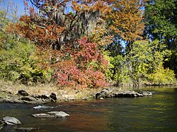
 Fall colors on the Coosa River near Wetumpka, Alabama | |
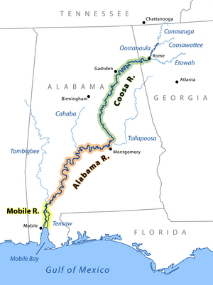
 The Coosa River is the major tributary when it joins the Tallapoosa River near Wetumpka, Alabama to form the Alabama River. | |
| Location | |
| Country | United States |
| State | Alabama, Georgia |
| Physical characteristics | |
| Source | Etowah River |
| • location | Suches, Georgia |
| • coordinates | 34°39′43″N 84°07′41″W / 34.662°N 84.128°W |
| • elevation | 2,677 ft (816 m) |
| 2nd source | Oostanaula River |
| • location | Dunn, Georgia |
| • coordinates | 34°53′06″N 84°34′23″W / 34.885°N 84.573°W |
| • elevation | ~ 730 feet (220 m)[1] |
| Mouth | Alabama River |
• location | Coosada, Alabama |
• coordinates | 32°29′10″N 86°16′40″W / 32.48611°N 86.27778°W[2] |
• elevation | 121 ft (37 m)[2] |
| Length | 280 mi (450 km)[3] |
| Basin size | 10,100 sq mi (26,000 km2)[4] |
| Discharge | |
| • location | USGS gage 02411000, Coosa River at Jordan Dam near Wetumpka, AL[5] |
| • average | 15,950 cu ft/s (452 m3/s)[5] |
| • minimum | 54 cu ft/s (1.5 m3/s) |
| • maximum | 256,000 cu ft/s (7,200 m3/s) |
 | |
The Coosa River is a tributary of the Alabama River in the U.S. states of Alabama and Georgia. The river is about 280 miles (450 km) long.[3]
The Coosa River begins at the confluence of the Oostanaula and Etowah rivers in Rome, Georgia, and ends just northeast of the Alabama state capital, Montgomery, where it joins the Tallapoosa River to form the Alabama River just south of Wetumpka. Around 90% of the Coosa River's length is located in Alabama. Coosa County, Alabama, is located on the Coosa River.
The Coosa is one of Alabama's most developed rivers. Most of the river has been impounded, with Alabama Power, a unit of the Southern Company, owning seven dams and powerhouses on the Coosa River. The dams produce hydroelectric power, but they are costly to some species endemic to the Coosa River.
- ^ U.S. Geological Survey. Dyer Gap quadrangle, GA. 1:24,000. 7.5 Minute Series. Washington D.C.: USGS, 1988.
- ^ a b U.S. Geological Survey Geographic Names Information System: Coosa River
- ^ a b U.S. Geological Survey. National Hydrography Dataset high-resolution flowline data. The National Map Archived 2016-06-30 at the Wayback Machine, accessed April 27, 2011
- ^ "Water resources data for the United States, Water Year 2009; gage 02411600, Coosa River at Wetumpka, AL" (PDF). USGS. Retrieved August 4, 2010.
- ^ a b "Water resources data for the United States, Water Year 2009; gage 02411000, Coosa River at Jordan Dam near Wetumpka, AL" (PDF). USGS. Retrieved August 4, 2010.