Back سلسلة جبال وسطى (سلسله جبليه فى امريكا) ARZ Cordillera Central (Puerto Rico) BCL Cordillera Central (kabukiran sa Purtoriko) CEB Cordillera Central (Puerto Rico) Spanish Cordillère Centrale (Porto Rico) French Cordillera Central (Porto Rico) Italian Cordillera Central (Puerto Rico) LLD Kordyliera Środkowa (Portoryko) Polish
| Cordillera Central | |
|---|---|
 Cordillera Central from the central municipality of Corozal | |
| Highest point | |
| Peak | Cerro de Punta |
| Elevation | 4,390 ft (1,340 m) |
| Coordinates | 18°10′21″N 66°35′31″W / 18.17250°N 66.59194°W |
| Geography | |
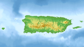
Location of Cerro de Punta in the Cordillera Central | |
| Location | |
| Region | Caribbean |
The Cordillera Central (English: "Central Mountain Range") is the only mountain range in the main island of Puerto Rico, consisting of three subranges: the western-central Cordillera Central, the southeastern Sierra de Cayey, and the northeastern Sierra de Luquillo. Bordered by the Northern Karst Belt to the northwest and costal plains to the north and south, the numerous ridges and foothills of the three subranges combined extend throughout the island. Concentrated in the western to central region of the island, the eponymous main subrange of Cordillera Central originates in the municipality of Mayagüez and merges with the Sierra de Cayey subrange on the town boundary between the municipalities of Barranquitas and Aibonito. At 1,338 meters (4,390 ft) on the town line between Ponce and Jayuya, Cerro de Punta is the summit of the Cordillera Central and the highest point in Puerto Rico.[1][2]

- ^ "Cordillera Central | mountains, Puerto Rico". Encyclopedia Britannica. Retrieved 2021-10-12.
- ^ "Fisiografia". www.recursosaguapuertorico.com. Retrieved 2021-10-12.
