Back مقاطعة كورتلاند (نيويورك) Arabic Cortland County, New York BAR Кортланд (окръг, Ню Йорк) Bulgarian কোর্টল্যান্ড কাউন্টি, নিউ ইয়র্ক BPY Cortland Gông (New York) CDO Кортленд (гуо, Нью-Йорк) CE Cortland County CEB Cortland County Czech Cortland County, Efrog Newydd Welsh Cortland County German
Cortland County | |
|---|---|
 Cortland County Courthouse | |
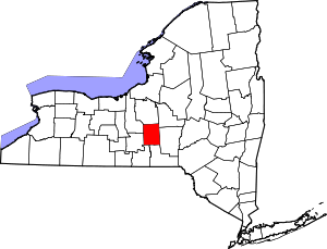
 Location within the U.S. state of New York | |
 New York's location within the U.S. | |
| Coordinates: 42°36′00″N 76°04′00″W / 42.6°N 76.0667°W | |
| Country | |
| State | |
| Founded | 1808 |
| Named for | Pierre Van Cortlandt |
| Seat | Cortland |
| Largest city | Cortland |
| Area | |
• Total | 502 sq mi (1,300 km2) |
| • Land | 499 sq mi (1,290 km2) |
| • Water | 2.8 sq mi (7 km2) 0.5% |
| Population (2020) | |
• Total | 46,809[1] |
| • Density | 93.8/sq mi (36.2/km2) |
| Time zone | UTC−5 (Eastern) |
| • Summer (DST) | UTC−4 (EDT) |
| Congressional district | 19th |
| Website | www |
Cortland County is a county located in the U.S. state of New York. As of the 2020 census, the population of Cortland County was 46,809.[2] The county seat is Cortland.[3] The county is named after Pierre Van Cortlandt, president of the convention at Kingston that wrote the first New York State Constitution in 1777, and first lieutenant governor of the state. The county is part of the Central New York region of the state.
Cortland County comprises the Cortland, NY Micropolitan Statistical Area, which is also included in the Ithaca–Cortland, NY Combined Statistical Area.
The Cortland apple is named for the county.[4]
- ^ "US Census 2020 Population Dataset Tables for New York". United States Census Bureau. Retrieved January 2, 2022.
- ^ "U.S. Census Bureau QuickFacts: Cortland County, New York". United States Census Bureau. Retrieved January 3, 2022.
- ^ "Find a County". National Association of Counties. Archived from the original on May 31, 2011. Retrieved June 7, 2011.
- ^ "Cortland". The State of New York. Retrieved March 30, 2020.
The Cortland variety of apple is named for the county.

