Back Difelinscīr ANG مقاطعة دبلن Arabic Condáu de Dublín AST Дъблин (графство) Bulgarian Kontelezh Dulenn Breton Comtat de Dublín Catalan Hrabství Dublin Czech Swydd Dulyn Welsh County Dublin Danish County Dublin German
County Dublin
Contae Bhaile Átha Cliath | |
|---|---|
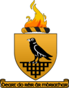
| Motto(s): Irish: Beart do réir ár mbriathar "Action to match our speech" | |
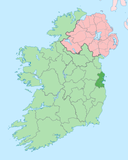
 County Dublin shown darker on the green of the Republic of Ireland, with Northern Ireland in pink | |
| Country | Ireland |
| Province | Leinster |
| Region | Eastern and Midland |
| Established | 1190s[1] |
| County town | Dublin |
| Government | |
| • Dáil constituencies | |
| • EP constituency | Dublin |
| Area | |
| • Total | 922 km2 (356 sq mi) |
| • Rank | 30th |
| Highest elevation (Kippure) | 757 m (2,484 ft) |
| Population (2022) | 1,458,154 |
| • Rank | 1st |
| • Density | 1,581.5/km2 (4,096/sq mi) |
| Demonym(s) | Dubliner Dub |
| Time zone | UTC±0 (GMT) |
| • Summer (DST) | UTC+1 (IST) |
| Eircode routing keys | D01–D18, D6W, D20, D22, D24, A41, A42, A45, A94, A96, K34, K45, K67, K78 |
| Telephone area codes | 01 |
| ISO 3166 code | IE-D |
| Vehicle index mark code | D |
 | |
County Dublin (Irish: Contae Bhaile Átha Cliath[2] or Contae Átha Cliath) is a county in Ireland, and holds its capital city, Dublin. It is located on the island's east coast, within the province of Leinster. Until 1994, County Dublin (excluding the city) was a single local government area; in that year, the county council was divided into three new administrative counties: Dún Laoghaire–Rathdown, Fingal and South Dublin. The three administrative counties together with Dublin City proper form a NUTS III statistical region of Ireland (coded IE061).[3] County Dublin remains a single administrative unit for the purposes of the courts (including the Dublin County Sheriff, but excluding the bailiwick of the Dublin City Sheriff) and Dublin County combined with Dublin City forms the Judicial County of Dublin, including Dublin Circuit Court, the Dublin County Registrar and the Dublin Metropolitan District Court. Dublin also sees law enforcement (the Garda Dublin metropolitan division) and fire services (Dublin Fire Brigade) administered county-wide.
Dublin is Ireland's most populous county, with a population of 1,458,154 as of 2022[update] – approximately 28% of the Republic of Ireland's total population.[4] Dublin city is the capital and largest city of the Republic of Ireland, as well as the largest city on the island of Ireland. Roughly 9 out of every 10 people in County Dublin lives within Dublin city and its suburbs.[5] Several sizeable towns that are considered separate from the city, such as Rush, Donabate and Balbriggan, are located in the far north of the county. Swords, while separated from the city by a green belt around Dublin Airport, is considered a suburban commuter town and an emerging small city.[6]
The third smallest county by land area, Dublin is bordered by Meath to the west and north, Kildare to the west, Wicklow to the south and the Irish Sea to the east. The southern part of the county is dominated by the Dublin Mountains, which rise to around 760 metres (2,500 ft) and contain numerous valleys, reservoirs and forests. The county's east coast is punctuated by several bays and inlets, including Rogerstown Estuary, Broadmeadow Estuary, Baldoyle Bay and most prominently, Dublin Bay. The northern section of the county, today known as Fingal, varies enormously in character, from densely populated suburban towns of the city's commuter belt to flat, fertile plains, which are some of the country's largest horticultural and agricultural hubs.
Dublin is the oldest county in Ireland, and was the first part of the island to be shired following the Norman invasion in the late 1100s. While it is no longer a local government area, Dublin retains a strong identity, and continues to be referred to as both a region and county interchangeably, including at government body level.[7][8]
- ^ "'Geographical loyalty'? Counties, palatinates, boroughs and ridings". 6 March 2013. Archived from the original on 23 June 2019. Retrieved 23 June 2019.
- ^ "Baile Átha Cliath/Dublin". logainm.ie. Archived from the original on 31 October 2013. Retrieved 12 July 2023.
- ^ "Revision to the Irish NUTS2 and NUTS3 regions". Central Statistics Office. Archived from the original on 13 November 2018. Retrieved 30 November 2018.
- ^ "FP005 Components of Population Change 2016 to 2022". 23 June 2022. Archived from the original on 25 August 2021. Retrieved 12 March 2023.
- ^ "Settlements – Dublin City and suburbs (2016 Census)". CSO. Archived from the original on 13 November 2018. Retrieved 26 June 2021.
- ^ Your Swords: An Emerging City : Strategic Vision 2035. Fingal County Council. Archived from the original on 12 July 2023. Retrieved 6 September 2022.
- ^ "DCOVID-19 14-day epidemiology reports- June 2021". HSE. Archived from the original on 30 June 2021. Retrieved 26 June 2021.
- ^ "Dublin Ranks 2nd Lowest for Government Capital Spending". Dublin Chamber of Commerce. Archived from the original on 26 June 2021. Retrieved 26 June 2021.
