Back Með ANG مقاطعة ميث Arabic Meath AST Мийт Bulgarian Kontelezh An Mhí Breton Comtat de Meath Catalan An Mhí CEB Hrabství Meath Czech Swydd Meath Welsh County Meath Danish
County Meath
Contae na Mí | |
|---|---|
| Nickname: The Royal County | |
| Motto(s): Irish: Tré Neart le Chéile "Stronger Together" | |
| Anthem: "Beautiful Meath" (unofficial) | |
 | |
| Country | Ireland |
| Province | Leinster |
| Region | Eastern and Midland |
| History | Date |
| Kingdom of Meath | Antiquity |
| Lordship of Meath | 1172 |
| Shired | 1297 |
| Division of Meath | 1542 |
| County town | Navan (1898–) Trim (1297–1898) |
| Government | |
| • Local authority | Meath County Council |
| • Dáil constituencies | |
| • EP constituency | Midlands–North-West |
| Area | |
| • Total | 2,342 km2 (904 sq mi) |
| • Rank | 14th |
| Highest elevation | 276 m (906 ft) |
| Population | |
| • Total | 220,826 |
| • Rank | 8th |
| • Density | 94/km2 (240/sq mi) |
| ISO 3166 code | IE-MH |
| Vehicle index mark code | MH |
| Website | Official website |
 | |
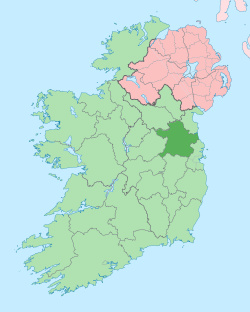
County Meath (/miːð/ MEEDH; Irish: Contae na Mí or simply an Mhí, lit. 'middle') is a county in the Eastern and Midland Region of Ireland, within the province of Leinster. It is bordered by County Dublin to the southeast, Louth to the northeast, Kildare to the south, Offaly to the southwest, Westmeath to the west, Cavan to the northwest, and Monaghan to the north. To the east, Meath also borders the Irish Sea along a narrow strip between the rivers Boyne and Delvin, giving it the second shortest coastline of any county. Meath County Council is the local authority for the county.
Meath is the 14th-largest of Ireland's 32 traditional counties by land area, and the 8th-most populous, with a total population of 220,826 according to the 2022 census.[2] The county town and largest settlement in Meath is Navan, located in the centre of the county along the River Boyne. Other towns in the county include Trim, Kells, Laytown, Ashbourne, Dunboyne, Slane and Bettystown.
Colloquially known as "The Royal County", the historic Kingdom of Meath was the seat of the High King of Ireland and, for a time, was also the island's fifth province. Ruled for centuries by the Southern Uí Néill dynasty, in the late 1100s the kingdom was invaded by the Anglo-Norman conqueror Hugh de Lacy, who ousted the Uí Néill and established himself as the Lord of Meath. This lordship gradually diminished in size before being formally shired as County Meath in 1297, which was further sub-divided into Meath and Westmeath in 1542. The county took its present boundaries in 1977, when much of Drogheda was transferred to County Louth.[3]
Meath has an abundance of historical sites, including the Hill of Tara, Hill of Slane, Newgrange, Knowth, Dowth, Loughcrew, the Abbey of Kells, Trim Castle and Slane Castle. The county was also the site of the seminal Battle of the Boyne, which was fought near Oldbridge in 1690, ending in the defeat of James II and his flight to France. It is the only county in Leinster to have Gaeltacht regions, at Ráth Chairn and Baile Ghib, and is also one of only two counties outside of the west of Ireland to have an official Gaeltacht (the other being County Waterford).
- ^ "Census 2022 – Summary Results – FY003A- Population". 30 May 2023. Retrieved 3 June 2023.
- ^ "Census of Population 2022 – Preliminary Results". Central Statistics Office (Ireland). 23 June 2022. Retrieved 26 May 2023.
- ^ Tully, James (19 October 1976). "Local Government Provisional Order Confirmation Act, 1976". Office of the Irish Attorney General. Archived from the original on 22 January 2009. Retrieved 22 March 2008.
