Back Crawley Afrikaans Crawley AN كرولي Arabic كرولى (بلده فى كراولى) ARZ Crawley AST Krouli Azerbaijani کراولی AZB Crawley Catalan Crawley (lungsod) CEB Crawley Czech
Crawley | |
|---|---|
| Borough of Crawley | |
The High Street, Queen's Square, Goff's Park House and the Memorial Gardens with the centre in the background | |
| Motto(s): "I Grow and I Rejoice" | |
| Coordinates: 51°6′33″N 0°11′14″W / 51.10917°N 0.18722°W | |
| Sovereign state | United Kingdom |
| Constituent country | England |
| Region | South East England |
| Ceremonial county | West Sussex |
| Historic county | Sussex (Town centre and outlying areas) Surrey (Gatwick Airport) |
| Admin HQ | Crawley Town Hall |
| Founded | 5th century |
| Borough status | 1974 |
| Government | |
| • Type | Borough |
| • Body | Crawley Borough Council |
| • Leadership | Leader and cabinet |
| • Council Leader | Cllr Michael Jones (L) |
| • Mayor | Cllr Sharmila Sivarajah (L) |
| • MPs | Peter Lamb (L) |
| Area | |
| • Borough | 17.36 sq mi (44.96 km2) |
| Population (2022) | |
| • Borough | 119,509 (ranked 200th) |
| • Density | 5,750/sq mi (2,221/km2) |
| Ethnicity (2021) | |
| • Ethnic groups | |
| Religion (2021) | |
| • Religion | List
|
| Time zone | UTC+0 (Greenwich Mean Time) |
| Postcode | |
| Area code | 01293 |
| ISO 3166-2 | GB-WSX (West Sussex) |
| ONS code | 45UE (ONS) E07000226 (GSS) |
| OS grid reference | TQ268360 |
| NUTS 3 | UKJ24 |
| Website | crawley |
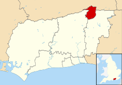
Crawley () is a town and borough in West Sussex, England. It is 28 miles (45 km) south of London, 18 miles (29 km) north of Brighton and Hove, and 32 miles (51 km) north-east of the county town of Chichester. Crawley covers an area of 17.36 square miles (44.96 km2) and had a population of 118,493 at the time of the 2021 Census.
The area has been inhabited since the Stone Age,[2] and was a centre of ironworking in Roman times. Crawley developed slowly as a market town from the 13th century, serving the surrounding villages in the Weald. Its location on the main road from London to Brighton brought passing trade, which encouraged the development of coaching inns. A rail link to London opened in 1841.
Gatwick Airport, one of Britain's busiest international airports, opened for commercial flights on the edge of the town in 1933, encouraging commercial and industrial growth. After the Second World War, the British Government planned to move large numbers of people and jobs out of London and into new towns around South East England. The New Towns Act 1946 (9 & 10 Geo. 6. c. 68) designated Crawley as the site of one of these.[3] A master plan was developed for the establishment of new residential, commercial, industrial and civic areas, and rapid development greatly increased the size and population of the town over a few decades.
The town contains 14 residential neighbourhoods radiating out from the core of the old market town, and separated by main roads and railway lines. The nearby communities of Ifield, Pound Hill and Three Bridges were absorbed into the new town at various stages in its development. In 2009, expansion was being planned in the west and north-west of the town, in cooperation with Horsham District Council, which has now become a new neighbourhood named Kilnwood Vale, but it is not in Crawley.[4] Economically, the town has developed into the main centre of industry and employment between London and the south coast. Its large industrial area supports manufacturing and service companies, many of them connected with the airport. The commercial and retail sectors continue to expand.[3]
- ^ a b UK Census (2021). "2021 Census Area Profile – Crawley Local Authority (E07000226)". Nomis. Office for National Statistics. Retrieved 5 January 2024.
- ^ Gwynne 1990, p. 9.
- ^ a b "Select Committee on Transport, Local Government and the Regions: Appendices to the Minutes of Evidence. Supplementary memorandum by Crawley Borough Council (NT 15(a))". United Kingdom Parliament Publications and Records website. The Information Policy Division, Office of Public Sector Information. 2002. Archived from the original on 17 July 2019. Retrieved 2 April 2008.
- ^ "West and North West of Crawley". Horsham District Council & Crawley Borough Council. 2006–2009. Archived from the original on 6 December 2007. Retrieved 29 October 2009.


