Back مقاطعة كريتيندين (أركنساس) Arabic كريتيندين كاونتى، اركانسو ARZ Crittenden County, Arkansas BAR Критъндън (окръг, Арканзас) Bulgarian ক্রিটেনডেন কাউন্টি, আরকান্সাস BPY Crittenden Gông (Arkansas) CDO Криттенден (гуо, Арканзас) CE Crittenden County (kondado sa Tinipong Bansa, Arkansas) CEB Crittenden County, Arkansas Welsh Crittenden County (Arkansas) German
35°43′16″N 90°04′51″W / 35.72111°N 90.08083°W
Crittenden County | |
|---|---|
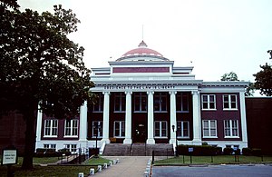
 Crittenden County Courthouse in Marion | |
 Location within the U.S. state of Arkansas | |
 Arkansas's location within the U.S. | |
| Coordinates: 35°14′N 90°18′W / 35.24°N 90.3°W | |
| Country | |
| State | |
| Founded | October 22, 1825 |
| Named for | Robert Crittenden |
| Seat | Marion |
| Largest city | West Memphis |
| Area | |
| • Total | 636 sq mi (1,650 km2) |
| • Land | 610 sq mi (1,600 km2) |
| • Water | 27 sq mi (70 km2) 4.2% |
| Population (2020) | |
| • Total | 48,163 |
| • Density | 76/sq mi (29/km2) |
| Time zone | UTC−6 (Central) |
| • Summer (DST) | UTC−5 (CDT) |
| Congressional district | 1st |
| Website | http://crittenden.ark.org/ |

Crittenden County is a county located in the U.S. state of Arkansas. As of the 2020 census, the population was 48,163.[1] The county seat is Marion,[2] and the largest city is West Memphis.
Crittenden County is part of the Memphis, TN-MS-AR Metropolitan Statistical Area. Most of the county's media comes from Memphis, although some Little Rock TV (Arkansas Educational Television Network, KATV) is imported by Comcast Cable. It lies within Arkansas's 1st congressional district.
- ^ "Census - Geography Profile: Crittenden County, Arkansas". United States Census Bureau. Retrieved January 19, 2023.
- ^ "Find a County". National Association of Counties. Archived from the original on May 31, 2011. Retrieved June 7, 2011.