Back Dagami BCL Dagami CBK-ZAM Dagami CEB Dagami German Dagami Spanish Dagami French Dagami ID Dagami ILO Dagami Italian დაგამი Georgian
Dagami | |
|---|---|
| Municipality of Dagami | |
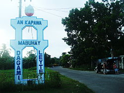
 Welcome sign | |
 Map of Leyte with Dagami highlighted | |
Location within the Philippines | |
| Coordinates: 11°03′40″N 124°54′11″E / 11.0611°N 124.9031°E | |
| Country | Philippines |
| Region | Eastern Visayas |
| Province | Leyte |
| District | 2nd district |
| Founded | 1565 |
| Barangays | 65 (see Barangays) |
| Government | |
| • Type | Sangguniang Bayan |
| • Mayor | Inday Delusa |
| • Vice Mayor | Bunny Bardillon |
| • Representative | Lolita T. Javier |
| • Councilors | List |
| • Electorate | 25,801 voters (2022) |
| Area | |
• Total | 161.65 km2 (62.41 sq mi) |
| Elevation | 210 m (690 ft) |
| Highest elevation | 1,322 m (4,337 ft) |
| Lowest elevation | 0 m (0 ft) |
| Population (2020 census)[4] | |
• Total | 36,178 |
| • Density | 220/km2 (580/sq mi) |
| • Households | 9,295 |
| Demonym | Dagamin-on |
| Economy | |
| • Income class | 3rd municipal income class |
| • Poverty incidence | 31.21 |
| • Revenue | ₱ 138.3 million (2020), 59.28 million (2012), 63.88 million (2013), 72.05 million (2014), 84.51 million (2015), 109.3 million (2016), 115.1 million (2017), 122.7 million (2018), 126.5 million (2019), 149.1 million (2021), 197.3 million (2022) |
| • Assets | ₱ 409.3 million (2020), 97.4 million (2012), 109.5 million (2013), 128.9 million (2014), 173.3 million (2015), 211.7 million (2016), 297.9 million (2017), 353.7 million (2018), 408.7 million (2019), 323.4 million (2021), 371.5 million (2022) |
| • Expenditure | ₱ 135.5 million (2020), 53.07 million (2012), 59.5 million (2013), 62.07 million (2014), 58.52 million (2015), 77.54 million (2016), 85.5 million (2017), 95.78 million (2018), 97.25 million (2019), 132.8 million (2021), 144.8 million (2022) |
| • Liabilities | ₱ 47.21 million (2020), 29.16 million (2012), 40.4 million (2013), 37.29 million (2014), 50.81 million (2015), 48.76 million (2016), 96.51 million (2017), 66.07 million (2018), 61.2 million (2019), 42.56 million (2021), 36.44 million (2022) |
| Service provider | |
| • Electricity | Don Orestes Romualdez Electric Coperative (DORELCO) |
| Time zone | UTC+8 (PST) |
| ZIP code | 6515 |
| PSGC | |
| IDD : area code | +63 (0)53 |
| Native languages | Waray Tagalog |
| Website | www |
Dagami (IPA: [dɐ'gami]), officially the Municipality of Dagami (Waray: Bungto han Dagami; Tagalog: Bayan ng Dagami), is a 3rd class municipality in the province of Leyte, Philippines. According to the 2020 census, it has a population of 36,178 people.[4]
Waray-Waray is the language spoken by the residents called Dagamin-on.
It is classified as a third class municipality and mere dependent on agriculture such as coconut, rice and corn farming. The employment rate is 63% of the total population workforce in the municipality. Its total land area of 161.5 square kilometers, equivalent to 16,165 hectares. More than half of its plains on the eastern side is cultivated for rice and corn farming while the western side is planted with coconut trees. Coconut production is a major source of income.Tubâ and copra - the white raw material from the coconut where coconut oil is extracted.
The town of Dagami is famous for its local delicacies called binagól (a distinct dessert made from sweetened large mashed taro called talian packed inside a leaf-covered coconut shell), and morón (a kind of sweetened rice cake, optionally added with peanuts or chocolate wrapped inside a banana leaf) and sagmani.
The town of Dagami, Leyte celebrates its feast every 27 May, to honor the town's patron, St. Joseph. They also celebrate this along with their festival, the Dinagamihan Festival[6]
- ^ Municipality of Dagami | (DILG)
- ^ "2015 Census of Population, Report No. 3 – Population, Land Area, and Population Density" (PDF). Philippine Statistics Authority. Quezon City, Philippines. August 2016. ISSN 0117-1453. Archived (PDF) from the original on May 25, 2021. Retrieved July 16, 2021.
- ^ https://en-us.topographic-map.com/maps/olw0/Dagami/.
{{cite web}}: Missing or empty|title=(help) - ^ a b Census of Population (2020). "Region VIII (Eastern Visayas)". Total Population by Province, City, Municipality and Barangay. Philippine Statistics Authority. Retrieved 8 July 2021.
- ^ "PSA Releases the 2021 City and Municipal Level Poverty Estimates". Philippine Statistics Authority. 2 April 2024. Retrieved 28 April 2024.
- ^ "Leyte". Philippine Information Agency. Archived from the original on 2019-07-29. Retrieved 2019-07-29.


