Back Národní park Donau-Auen Czech Donau-Auen Nationalpark Danish Nationalpark Donau-Auen German Parque nacional Danubio-Auen Spanish Tonava-Auenin kansallispuisto Finnish Parc national Danube-Auen French הפארק הלאומי דונאו-אאואן HE Donau-Auen Nemzeti Park Hungarian Դոնաու-Աուեն Armenian Parco nazionale Danubio-Auen Italian
| Donau-Auen National Park | |
|---|---|
 Donau-Auen near Hainburg | |
 | |
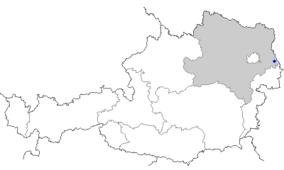
| Location | Vienna and Lower Austria |
| Nearest city | Vienna |
| Coordinates | 48°8′N 16°55′E / 48.133°N 16.917°E |
| Area | 93 km2 (36 sq mi) |
| Established | October 27, 1996 |


Donau-Auen National Park (German: Nationalpark Donau-Auen) covers 93 square kilometres in Vienna and Lower Austria and is one of the largest remaining floodplains of the Danube in Middle Europe.
The German word Aue (variant Au) means "river island, wetland, floodplain, riparian woodland", i.e. a cultivated landscape in a riparian zone. The words Aue and Au occur in a large number of German place names—including Donau, the German word for the Danube River—and refer to forests, meadows, and wetlands in river and stream lowlands and floodplains. The Danube-Auen National Park protects a large area of lowland forests, meadows, wetlands, and other riparian habitat along the Danube just downstream of Vienna.
The Park was designated an IUCN category II national park and spans the areas of Vienna (Lobau), Groß-Enzersdorf, Orth an der Donau, Eckartsau, Engelhartstetten, Hainburg, Bad Deutsch-Altenburg, Petronell-Carnuntum, Regelsbrunn, Haslau-Maria Ellend, Fischamend and Schwechat.
