Back Dardanelle Afrikaans Dardanelos AN Ellaspontus ANG الدردنيل Arabic الدردنيل ARZ Dardanelos AST Dardanel Azerbaijani Дарданелл боғаҙы Bashkir Дарданэлы Byelorussian Дарданэлы BE-X-OLD
| Dardanelles | |
|---|---|
| Strait of Gallipoli | |
| Çanakkale Boğazı (Turkish) | |
 Close-up topographic map of the Dardanelles | |
| Coordinates | 40°12′N 26°24′E / 40.2°N 26.4°E |
| Type | Strait |
| Part of | Turkish Straits |
| Basin countries | Turkey |
| Max. length | 61 km (38 mi) |
| Min. width | 1.2 km (0.75 mi) |


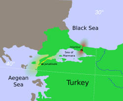
The Dardanelles (/ˌdɑːrdəˈnɛlz/ DAR-də-NELZ; Turkish: Çanakkale Boğazı, lit. 'Strait of Çanakkale'; Greek: Δαρδανέλλια, romanized: Dardanéllia), also known as the Strait of Gallipoli (after the Gallipoli peninsula) and in Classical Antiquity as the Hellespont (/ˈhɛlɪspɒnt/ HEL-isp-ont; Classical Greek: Ἑλλήσποντος, romanized: Hellḗspontos, lit. 'Sea of Helle'), is a narrow, natural strait and internationally significant waterway in northwestern Turkey that forms part of the continental boundary between Asia and Europe and separates Asian Turkey from European Turkey. Together with the Bosporus, the Dardanelles forms the Turkish Straits.
One of the world's narrowest straits used for international navigation, the Dardanelles connects the Sea of Marmara with the Aegean and Mediterranean seas while also allowing passage to the Black Sea by extension via the Bosporus. The Dardanelles is 61 kilometres (38 mi) long and 1.2 to 6 kilometres (0.75 to 3.73 mi) wide. It has an average depth of 55 metres (180 ft) with a maximum depth of 103 metres (338 ft) at its narrowest point abreast the city of Çanakkale. The first fixed crossing across the Dardanelles opened in 2022 with the completion of the 1915 Çanakkale Bridge.
Most of the northern shores of the strait along the Gallipoli peninsula (Turkish: Gelibolu) are sparsely settled, while the southern shores along the Troad peninsula (Turkish: Biga) are inhabited by the city of Çanakkale's urban population of 110,000.

