Back Denbiscīr ANG Sir Ddinbych (hanesyddol) Welsh Denbighshire Kurdish Denbighiensis comitatus Latin
| Denbighshire Sir Ddinbych (Welsh) | |
|---|---|
| Area | |
| • 1831 | 386,052 acres (1,562.30 km2) |
| • 1911 | 426,084 acres (1,724.30 km2)[1] |
| • 1961 | 427,978 acres (1,731.97 km2)[1] |
| Population | |
| • 1831 | 83,629[2] |
| • 1911 | 144,783[1] |
| • 1961 | 174,151[1] |
| Density | |
| • 1831 | 0.2/acre |
| • 1911 | 0.3/acre |
| • 1961 | 0.4/acre |
| Chapman code | DEN |
| Government | Denbighshire County Council (1889–1974) |
| • HQ | Denbigh and Ruthin |
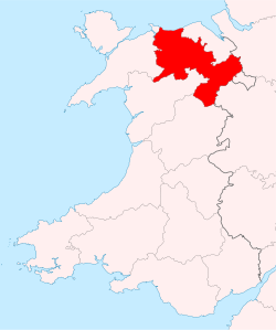
Until 1974, Denbighshire (Welsh: Sir Ddinbych), or the County of Denbigh, was an administrative county in the north of Wales, later classed as one of the thirteen historic counties of Wales. It was a maritime county, that was bounded to the north by the Irish Sea, to the east by Flintshire, Cheshire and Shropshire, to the south by Montgomeryshire and Merionethshire, and to the west by Caernarfonshire.
Under the Local Government Act 1972, the use of Denbighshire for local government and ceremonial purposes ended on 1 April 1974, with the creation of the new county of Clwyd. A different county of the same name was created on 1 April 1996, for modern local government purposes, covering a substantially different area from the historic county.
- ^ a b c d Vision of Britain - Denbighshire population (area and density)
- ^ Vision of Britain - 1831 Census


