Back দিউ জেলা Bengali/Bangla Diu (distrito) CEB بخش دیو Persian District de Diu French દીવ જિલ્લો Gujarati दीव ज़िला Hindi Distretto di Diu Italian Diu (district) Dutch Diu (distrikt) NB Diu (dystrykt) Polish
Diu district
Distrito de Dio[1] | |
|---|---|
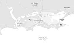
 Map of Diu district, the exclave of Simbor is not shown | |
| Coordinates: 20°43′N 70°59′E / 20.71°N 70.98°E | |
| Country | |
| Union Territory | |
| Founded by | Francisco de Almeida |
| Headquarter | Diu town |
| Area | |
| • Total | 40 km2 (20 sq mi) |
| Elevation | 30 m (100 ft) |
| Population (2011) | |
| • Total | 52,074 |
| • Density | 1,300/km2 (3,400/sq mi) |
| Demonym | Diucar/ Diuese[2][3] |
| Languages[4] | |
| • Official | Hindi, English |
| • Other | Gujarati, Portuguese[5][6][7] |
| Website | http://diu.gov.in/ |
Diu district /ˈdiːuː/ is one of the three districts of the union territory of Dadra and Nagar Haveli and Daman and Diu of India.[8] The district is made up of Diu Island and two small enclaves of Simbor and Gogola, at the border with the state of Gujarat. The district headquarters are at Diu Town. It is the ninth least populous district in the country (out of 640).[9]
- ^ Almeida, José C. (1965). "Alguns aspectos demograficos de Goa, Damao e Dio: Some demographic aspects of Goa, Daman & Diu".
- ^ "Survey chapter: Diu Indo-Portuguese".
- ^ "Diu Indo-Portuguese at present".
- ^ "52nd Report of the Commissioner for Linguistic Minorities in India" (PDF). 29 March 2016. p. 87. Archived from the original (PDF) on 25 May 2017. Retrieved 15 January 2018.
- ^ "District at a Glance".
- ^ "Survey chapter: Diu Indo-Portuguese".
- ^ "Firangiwada Heritage Walk".
- ^ "Dadra & Nagar Haveli and Daman & Diu UTs merge for 'better admin efficiency, service': MoS Home". Indus Dictum. 4 December 2019. Archived from the original on 11 November 2021. Retrieved 4 January 2021.
- ^ "District Census 2011". Census2011.co.in. 2011. Retrieved 30 September 2011.
