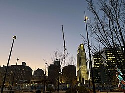
Downtown Omaha | |
|---|---|
 View of Downtown Omaha looking west from the Gene Leahy Mall | |
| Nickname(s): Gateway to the West, the Big O | |
 | |
| Coordinates: 41°15′30″N 95°56′31″W / 41.2583039°N 95.9418751°W | |
| Country | United States |
| State | Nebraska |
| Counties | Douglas County |
| City | Omaha |
| Area | |
| • Total | 0.72 sq mi (1.86 km2) |
| • Land | 0.70 sq mi (1.81 km2) |
| • Water | 0.02 sq mi (0.05 km2) 2.78% |
| Elevation | 1,090 ft (330 m) |
| Population (2010) | |
| • Total | 10,334 |
| • Density | 14,353/sq mi (5,709/km2) |
| ZIP code | 68102 |
| Area code(s) | 402, 531 |
| Website | omahadowntown |

Downtown Omaha is the central business, government and social core of the Omaha–Council Bluffs metropolitan area, U.S. state of Nebraska. The boundaries are Omaha's 20th Street on the west to the Missouri River on the east and the centerline of Leavenworth Street on the south to the centerline of Chicago Street on the north, also including the CHI Health Center Omaha.[1] Downtown sits on the Missouri River, with commanding views from the tallest skyscrapers.
Dating almost to the city's inception, downtown has been a popular location for the headquarters of a variety of companies. The Union Pacific Railroad has been headquartered in Omaha since its establishment in 1862. Downtown Omaha was also the site of the Jobbers Canyon Historic District, which housed 24 historic warehouses. All 24 buildings were demolished in 1989, representing the largest single loss of buildings to date from the National Register.[2] The site was home to many import and export businesses necessary for the settlement and development of the American West.
Today dozens of companies have their national and regional headquarters in downtown Omaha.[3] The area is home to more than 30 buildings listed on the National Register of Historic Places, along with two historic districts.
- ^ Frequently Asked Questions. Downtown Business Improvement District. Retrieved 8/19/07.
- ^ Gratz, R.B. (1996) Living City: How America's Cities Are Being Revitalized by Thinking Small in a Big Way. John Wiley and Sons. p. V.
- ^ Marcec, D. (2007) "Middle market highlight: April 2007: Omaha. Heartland Real Estate Business. Retrieved 8/22/07.
