Back وادي درعة Arabic واد درعة ARY وادی درعه چایی AZB Дра Byelorussian Драа Bulgarian Draa Breton Riu Draa Catalan Oued Drâa CEB Dra Czech Уэд-Драа CV
| Draa River fleuve du Draa (French) Río Draa (Spanish) | |
|---|---|
 | |
 | |
| Native name |
|
| Location | |
| Countries | |
| Physical characteristics | |
| Source | Dadès River |
| 2nd source | Imini River |
| Mouth | Atlantic |
| Length | 1100km |
| Basin features | |
| Progression | Southeast |
| Official name | Embouchure de l'oued Dr'a |
| Designated | 15 January 2005 |
| Reference no. | 1477[1] |
| Official name | Moyenne Dr'a |
| Designated | 15 January 2005 |
| Reference no. | 1482[2] |
 | |
- Dra is also the abbreviation for the constellation Draco.
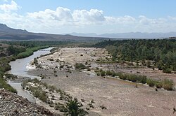
The Draa (Berber languages: Asif en Dra, ⴰⵙⵉⴼ ⴻⵏ ⴷⵔⴰ, Moroccan Arabic: واد درعة, romanized: wad dərʿa; also spelled Dra or Drâa, in older sources mostly Darha or Dara, Latin: Darat) is Morocco's longest river, at 1,100 kilometres (680 mi). It is formed by the confluence of the Dadès River and Imini River. It flows from the High Atlas mountains, initially south-eastward to Tagounite, and from Tagounite mostly westwards to its mouth in the Atlantic Ocean somewhat north of Tan-Tan. In 1971, the (El) Mansour Eddahabi dam was constructed to service the regional capital of Ouarzazate and to regulate the flow of the Draa. Most of the year the part of the Draa after Tagounite falls dry.
In the first half of the 20th century, the lowest course of the Draa marked the boundary between the French protectorate of Morocco and the area under Spanish rule.
The valley contains the Fezouata formations, which are Burgess shale-type deposits dating to the Lower Ordovician, filling an important preservational window between the common Cambrian lagerstätten and the Late Ordovician Soom shale.[3] In the fossilized fauna were numerous organisms previously thought to have died out after the mid-Cambrian.[4]
- ^ "Embouchure de l'oued Dr'a". Ramsar Sites Information Service. Archived from the original on 30 May 2018. Retrieved 25 April 2018.
- ^ "Moyenne Dr'a". Ramsar Sites Information Service. Archived from the original on 27 February 2017. Retrieved 25 April 2018.
- ^ Van Roy, P.; Orr, P. J.; Botting, J. P.; Muir, L. A.; Vinther, J.; Lefebvre, B.; Hariri, K. E.; Briggs, D. E. G. (2010). "Ordovician faunas of Burgess Shale type". Nature. 465 (7295): 215–8. Bibcode:2010Natur.465..215V. doi:10.1038/nature09038. PMID 20463737. S2CID 4313285. Archived from the original on 2024-02-25. Retrieved 2024-02-24.
- ^ Gill, Victoria (13 May 2010). "BBC News - Fossil find resolves ancient extinction mystery". BBC Online. British Broadcasting Corporation. Archived from the original on 2 February 2020. Retrieved 2 September 2015.