Back مقاطعة دوبيج (إلينوي) Arabic دوپئیج بؤلگهسی، ایلینوی AZB DuPage County, Illinois BAR Дупейдж (окръг, Илинойс) Bulgarian ডুপেইজ কাউন্টি, ইলিনয়স BPY Comtat de DuPage Catalan DuPage Gông (Illinois) CDO DuPage County CEB DuPage County, Illinois Welsh DuPage County German
DuPage County | |
|---|---|
County | |
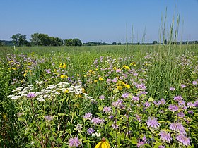
Warrenville Grove Forest Preserve on the West Branch of the DuPage River; Restored tallgrass prairie in Dunham Forest Preserve | |
| Motto: The Magnificent Miles West of Chicago | |
 Location within the U.S. state of Illinois | |
 Illinois's location within the U.S. | |
| Coordinates: 41°51′07″N 88°05′08″W / 41.85195°N 88.08567°W | |
| Country | |
| State | |
| Founded | February 9, 1839 |
| Named for | DuPage River |
| Seat | Wheaton |
| Largest city | Aurora[a] |
| Area | |
| • Total | 336 sq mi (870 km2) |
| • Land | 327 sq mi (850 km2) |
| • Water | 8.9 sq mi (23 km2) 2.6% |
| Population (2020) | |
| • Total | 932,877 |
| • Density | 2,800/sq mi (1,100/km2) |
| Time zone | UTC−6 (Central) |
| • Summer (DST) | UTC−5 (CDT) |
| Area code | 630 and 331 |
| Congressional districts | 3rd, 4th, 6th, 8th, 11th |
| Website | www |
| [1] | |
DuPage County (/duːˈpeɪdʒ/ doo-PAYJ) is a county in the U.S. state of Illinois, and one of the collar counties of the Chicago metropolitan area. As of the 2020 census, the population was 932,877, making it Illinois' second-most populous county. Its county seat is Wheaton.[2]
Known for its vast tallgrass prairies,[3] DuPage County has become mostly developed and suburbanized, although some pockets of farmland remain in the county's western and northern parts.[4] Located in the Rust Belt, the area is one of few in the region whose economy quickly became dependent on the headquarters of several large corporations due to its close proximity to Chicago. As quarries closed in the 1990s, land that was formerly used for mining and plants was converted into mixed-use, master-planned developments to meet the growing tax base.[5] The county has a mixed socioeconomic profile and residents of Hinsdale, Naperville and Oak Brook include some of the wealthiest people in the Midwest. On the whole, the county enjoys above average median household income levels and low overall poverty levels when compared to the national average.[6] In 2023, Niche ranked four DuPage municipalities (Clarendon Hills at #125, Naperville at #130, Hinsdale at #166, and Lisle at #280) amongst the best places to live in America.[7]
Cite error: There are <ref group=lower-alpha> tags or {{efn}} templates on this page, but the references will not show without a {{reflist|group=lower-alpha}} template or {{notelist}} template (see the help page).
- ^ "DuPage County". Geographic Names Information System. United States Geological Survey, United States Department of the Interior.
- ^ "Find a County". National Association of Counties. Archived from the original on May 31, 2011. Retrieved June 7, 2011.
- ^ Robertson, Ken. "Tallgrass Prairie: Where to see prairies". Illinois Natural History Survey. Retrieved October 24, 2023.
- ^ Kuethe, T. (April 26, 2019). "Changes in Farms and Farmland in Illinois". farmdoc daily. 9 (76). Department of Agricultural and Consumer Economics, University of Illinois at Urbana-Champaign.
- ^ "Cantera Development". City of Warrenville, Illinois. Retrieved October 24, 2023.
- ^ "DuPage County, IL". Data USA. Retrieved October 22, 2018.
- ^ "2023 Best Places to Live in America". Niche. Retrieved October 24, 2023.


