Back دوندالك (ماريلند) Arabic دوندالك (منطقه فى امريكا) ARZ دوندالک، مریلند AZB Dundalk (lungsod) CEB Dundalk (Maryland) German Dundalk (Maryland) Spanish Dundalk (Maryland) Basque داندک، مریلند Persian Dundalk (Maryland) French دانداک (مريلند) GLK
This article needs additional citations for verification. (December 2008) |
Dundalk | |
|---|---|
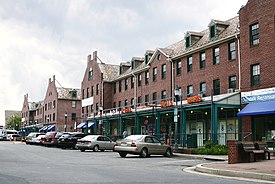
 The Dundalk Shopping Center, in May 2006. | |
 Location in the U.S. state of Maryland | |
| Coordinates: 39°15′57″N 76°30′19″W / 39.26583°N 76.50528°W | |
| Country | |
| State | |
| County | |
| Founded | 1856 |
| Area | |
| • Total | 17.41 sq mi (45.10 km2) |
| • Land | 13.09 sq mi (33.90 km2) |
| • Water | 4.33 sq mi (11.20 km2) |
| Elevation | 16 ft (5 m) |
| Population (2020) | |
| • Total | 67,796 |
| • Density | 5,180.01/sq mi (2,000.08/km2) |
| Time zone | UTC-5 (EST) |
| • Summer (DST) | UTC-4 (EDT) |
| ZIP code | 21222 |
| Area code(s) | 410, 443, 667 |
| FIPS code | 24-23975 |
| GNIS feature ID | 0590117 |
Dundalk (/ˈdʌndɔːk/ DUN-dawk or /ˈdʌndɒk/ DUN-dok) is an unincorporated community and census-designated place in Baltimore County, Maryland, United States. The population was 67,796 at the 2020 census.[2] In 1960 and 1970, Dundalk was the largest unincorporated community in Maryland. It was named after the town of Dundalk (Irish: Dún Dealgan) in County Louth, Ireland. Dundalk is considered one of the first inner-ring suburbs of Baltimore.
- ^ "2020 U.S. Gazetteer Files". United States Census Bureau. Retrieved April 26, 2022.
- ^ "Profile of General Population and Housing Characteristics: 2020 Demographic Profile Data (DP-1): Dundalk CDP, Maryland". United States Census Bureau. Retrieved February 22, 2012.
