Back المنطقة الشرقية (الكاميرون) Arabic KamerunaEstGola AVK Усходні рэгіён (Камерун) Byelorussian Усходні рэгіён (Камэрун) BE-X-OLD Източен регион (Камерун) Bulgarian Regió Est (Camerun) Catalan East Region CEB Est (Kamerun) German Orienta Kameruno Esperanto Región del Este (Camerún) Spanish
This article includes a list of general references, but it lacks sufficient corresponding inline citations. (August 2009) |
East Region | |
|---|---|
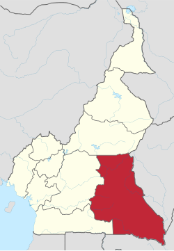
 Location of East Region within Cameroon | |
| Coordinates: 4°00′N 14°00′E / 4.000°N 14.000°E | |
| Country | Cameroon |
| Capital | Bertoua |
| Departments | Boumba-et-Ngoko, Haut-Nyong, Kadey, Lom-et-Djérem |
| Government | |
| • Governor | Gregoire Mvongo[1] |
| Area | |
• Total | 109,002 km2 (42,086 sq mi) |
| Population (2015) | |
• Total | 835,642 |
| • Density | 7.7/km2 (20/sq mi) |
| HDI (2022) | 0.543[2] low · 7th of 10 |
The East Region (French: Région de l'Est) occupies the southeastern portion of the Republic of Cameroon. It is bordered to the east by the Central African Republic, to the south by Congo, to the north by the Adamawa Region, and to the west by the Centre and South Regions. With 109,002 km2 of territory, it is the largest region in the nation as well as the most sparsely populated. Historically, the peoples of the East have been settled in Cameroonian territory for longer than any other of the country's many ethnic groups, the first inhabitants being the Baka (or Babinga) pygmies.
The East Region has very little industry, its main commerce consisting of logging, timber, and mining. Instead, the bulk of its inhabitants are subsistence farmers. The region is thus of little political import and is often ignored by Cameroonian politicians. This coupled with the low level of development in the province have led to its being dubbed "the forgotten province".
The southwest region is the most endowed with natural resources like oil, timber and plantain plantation
- ^ "- CRTV". Archived from the original on 2017-11-13. Retrieved 2017-11-13.
- ^ "Sub-national HDI - Area Database - Global Data Lab". hdi.globaldatalab.org. Retrieved 2018-09-13.