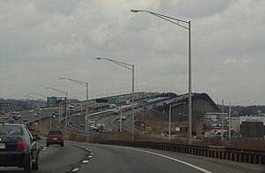
Edison Bridge | |
|---|---|
 The Driscoll Bridge (left) Vieser bridge(middle) and the Edison Bridge (right). | |
| Coordinates | 40°30′32″N 74°18′02″W / 40.50889°N 74.30056°W |
| Carries | 6 lanes of |
| Crosses | Raritan River |
| Locale | Woodbridge, New Jersey and Sayreville, New Jersey |
| Official name | Thomas Alva Edison Memorial Bridge |
| Other name(s) | Ellis S. Vieser Memorial Bridge |
| Maintained by | NJDOT |
| Characteristics | |
| Design | Girder |
| Total length | 4,391 feet (1,338 m) |
| No. of spans | 29 |
| History | |
| Construction start | September 26, 1938 |
| Opened | October 11, 1940 |
| Inaugurated | December 14, 1940 |
| Location | |
 | |
The Edison Bridge (officially the Thomas Alva Edison Memorial Bridge) and the Vieser bridge (officially the Ellis S. Vieser Memorial Bridge) are a pair of bridges that carry U.S. Route 9 in the state of New Jersey, spanning the Raritan River near its mouth in Raritan Bay. The bridge, which connects Woodbridge on the north with Sayreville on the south, was opened to weekend traffic starting on October 11, 1940, and was opened permanently on November 15, 1940.[1] As of 2003, the bridge carries more than 82,000 vehicles daily and is owned and operated by the New Jersey Department of Transportation. It also runs directly parallel to the Driscoll Bridge, which carries the Garden State Parkway.
