| Everton Queensland—Legislative Assembly | |||||||||||||||
|---|---|---|---|---|---|---|---|---|---|---|---|---|---|---|---|
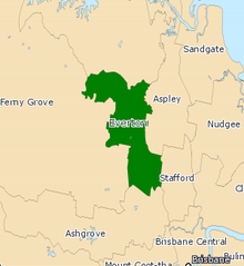
 Everton electoral district map 2017 | |||||||||||||||
| State | Queensland | ||||||||||||||
| Dates current | 1972–present | ||||||||||||||
| MP | Tim Mander | ||||||||||||||
| Party | Liberal National | ||||||||||||||
| Namesake | Everton Park | ||||||||||||||
| Electors | 37,520 (2020) | ||||||||||||||
| Area | 48 km2 (18.5 sq mi) | ||||||||||||||
| Demographic | Outer-metropolitan | ||||||||||||||
| Coordinates | 27°22′S 152°57′E / 27.367°S 152.950°E | ||||||||||||||
| |||||||||||||||

Everton is an electoral district of the Legislative Assembly in the Australian state of Queensland.[1]
The division encompasses suburbs in Brisbane's north west between Kedron Brook and the South Pine River, including Everton Park, Everton Hills, McDowall and Albany Creek. Parts of Mitchelton are located in the electorate.
- ^ "Representatives of Queensland State Electorates 1860-2017" (PDF). Queensland Parliamentary Record 2012-2017: The 55th Parliament. Queensland Parliament. Archived from the original (PDF) on 27 April 2020. Retrieved 27 April 2020.
