Back الإقليم الاستوائي Arabic Екватория Bulgarian Equatòria Catalan Equatoria Czech Äquatoria German Ecuatoria (región) Spanish استان اکواتوریا Persian Équatoria French אקווטוריה HE Equatoria Croatian
Equatoria | |
|---|---|
Region | |
| Motto: God Is Our Strength | |
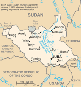
 Location in South Sudan | |
| Country | South Sudan |
| Region | Equatoria |
| Province of Anglo-Egyptian Sudan | 1870 |
| Capital | Juba |
| Area | |
| • Total | 195,847.67 km2 (75,617.21 sq mi) |
| Population (2014 estimate) | |
| • Total | 3,399,400 |
| • Density | 17/km2 (45/sq mi) |
| Time zone | UTC+2 (CAT) |
| Area code | 211 |

Equatoria is the southernmost region of South Sudan, along the upper reaches of the White Nile and the border between South Sudan and Uganda. Juba, the national capital and the largest city in South Sudan, is located in Equatoria. Originally a province of Anglo-Egyptian Sudan, it also contained most of northern parts of present-day Uganda, including Lake Albert and West Nile. It was an idealistic effort to create a model state in the interior of Africa that never consisted of more than a handful of adventurers and soldiers in isolated outposts.[1]
Equatoria was established by Samuel Baker in 1870. Charles George Gordon took over as governor in 1874, followed by Emin Pasha in 1878. The Mahdist Revolt put an end to Equatoria as an Egyptian outpost in 1889. Later British Governors included Martin Willoughby Parr. Important towns in Equatoria included Lado, Gondokoro, Dufile and Wadelai. The last two former areas of Equatoria, Lake Albert and West Nile are now situated in Uganda.
Under Anglo-Egyptian rule, most of Equatoria became one of the eight original provinces of Sudan. The region of Bahr el Ghazal was split from Equatoria in 1948. In 1976, Equatoria was further split into the provinces of East and West Equatoria. The region has been troubled with violence during both the First and Second Sudanese Civil Wars, as well as the anti-Ugandan insurgencies based in Sudan such as the Lord's Resistance Army and West Nile Bank Front.
- ^ Moorehead, Alan (2000). The White Nile (First ed.). New York: Harper Perennial. p. 448. ISBN 978-0060956394.