Back فار راکوی، کویینز AZB Far Rockaway, Queens Welsh Far Rockaway German فار راکاوی، کویینز Persian Far Rockaway French פאר רוקאוויי HE Far Rockaway, Queens SIMPLE Far Rockaway Swedish فار روک اوے، کوئینز Urdu פאר ראקעוועי YI
Far Rockaway | |
|---|---|
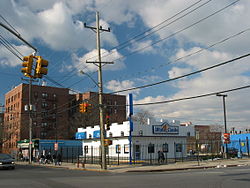
 Far Rockaway in 2005 | |
 Location within New York City | |
| Coordinates: 40°36′04″N 73°45′25″W / 40.601°N 73.757°W | |
| Country | |
| State | |
| City | New York City |
| County/Borough | Queens |
| Community District | Queens 14[1] |
| Named for | Place name of the Native American Lenape. |
| Population (2010) | |
• Total | 50,058 |
| Ethnicity | |
| • Non-Hispanic White | 25.5% |
| • Black or African-American | 44.7% |
| • Hispanic or Latino of any race | 24.7% |
| • Asian | 1.9% |
| • Other | 1.4% |
| • Two or more races | 1.7% |
| Economics | |
| • Median income | $27,820 |
| Time zone | UTC−5 (EST) |
| • Summer (DST) | UTC−4 (EDT) |
| ZIP Code | 11691, 11693[2] |
| Area codes | 718, 347, 929, and 917 |
Far Rockaway is a neighborhood on the eastern part of the Rockaway peninsula in the New York City borough of Queens. It is the easternmost section of the Rockaways. The neighborhood extends from Beach 32nd Street east to the Nassau County line. Its southern boundary is the Atlantic Ocean; it is one of the neighborhoods along Rockaway Beach.
Far Rockaway is located in Queens Community District 14 and its ZIP Codes are 11691 and 11693.[1] It is patrolled by the New York City Police Department's 101st Precinct.
- ^ a b "NYC Planning | Community Profiles". communityprofiles.planning.nyc.gov. New York City Department of City Planning. Archived from the original on June 22, 2019. Retrieved April 7, 2018.
- ^ "Far Rockaway ZIP Code Map". zipdatamaps.com. 2022. Archived from the original on November 3, 2022. Retrieved November 3, 2022.