Back 10.º distrito congresional de Florida Spanish حوزه انتخابیه دهم فلوریدا Persian Dixième district congressionnel de Floride French
| Florida's 10th congressional district | |
|---|---|
Interactive map of district boundaries since January 3, 2023 | |
| Representative | |
| Area | 516[1] sq mi (1,340 km2) |
| Distribution |
|
| Population (2023) | 784,303[3] |
| Median household income | $68,821[4] |
| Ethnicity |
|
| Cook PVI | D+14[5] |
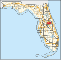
Florida's 10th congressional district is a congressional district in the U.S. state of Florida. It was reassigned in 2012, effective January 3, 2013, from the Gulf Coast to inland Central Florida. Before 2017, the district included parts of western Orange County, most of Lake County, as well as a northern section of Polk County. The current district is entirely within Orange County, and covers most of its western portion. It is situated along the Interstate 4 corridor. It includes most of the western half of Orlando. Other cities and towns wholly or partly within the district include Apopka, Belle Isle, Beulah, Eatonville, Harlem Heights, Ocoee, Oak Ridge, Orlo Vista, Winter Garden, and Windermere. In 2020, the district was expanded further north and south to include most of Orlando east of Interstate 4, the Baldwin Park area (redevelopment of the former Naval Training Center Orlando), Orlando Executive Airport, Winter Park, that portion of Maitland within Orange County, the Azaela Park, Goldenrod, Rio Pinar and Alafaya/Waterford Lakes areas, and continuing east to the University of Central Florida, Naval Support Activity Orlando, the Central Florida Research Park, and the Lake Pickett, Bithlo and Wedgefield areas. Even with this expansion, the 10th remains a minority majority district.[6][7][needs update]
It is currently represented by Democrat Maxwell Frost. Due to redistricting after the 2010 census, this district was re-numbered, and slightly reconfigured from the former 8th district. Prior to 2017, it was considered a swing district with a slight Republican tilt. Due to mid-decade redistricting that occurred in 2016, the district became much more compact. It is now considered solidly Democratic.
The former 10th district, during 2003–2012, covered areas further west and encompassed much of Pinellas County, on the Gulf coast of central Florida.
- ^ "Congressional Plan--SC14-1905 (Ordered by The Florida Supreme Court, 2-December-2015)" (PDF). Florida Senate Committee on Reapportionment. Retrieved January 11, 2017.
- ^ "Congressional Districts Relationship Files (State-based)". U.S. Census Bureau. Archived from the original on April 2, 2013.
- ^ Bureau, Center for New Media & Promotion (CNMP), US Census. "My Congressional District". www.census.gov.
{{cite web}}:|last=has generic name (help)CS1 maint: multiple names: authors list (link) - ^ "My Congressional District".
- ^ "2022 Cook PVI: District Map and List". Cook Political Report. July 12, 2022. Retrieved January 10, 2023.
- ^ See whole Florida state map for 2013, with the 10th district covering Lake County, west Orange and north Polk County: h9047_35x42L.pdf Congressional Plan: H000C9047. Chapter No. 2012-2, Laws of Florida. www.flsenate.gov. February 16, 2012.
- ^ See 2013 borders of 10th district in Lake County plus north Polk and western Orange County in the 2013 districts map: H000C9047_map_ec.pdf, for the Eastern Central region of Florida. Congressional Plan: H000C9047. Chapter No. 2012-2, Laws of Florida. www.flsenate.gov. February 2012.

