Back 12.º distrito congresional de Florida Spanish حوزه انتخابیه دوازدهم فلوریدا Persian Douzième district congressionnel de Floride French
| Florida's 12th congressional district | |
|---|---|
Interactive map of district boundaries since January 3, 2023 | |
| Representative | |
| Area | 1,069[1] sq mi (2,770 km2) |
| Distribution |
|
| Population (2023) | 843,806[3] |
| Median household income | $63,762[3] |
| Ethnicity |
|
| Cook PVI | R+17[4] |
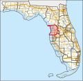
Florida's 12th congressional district is an electoral district for the U.S. Congress and was assigned along the Gulf coast of central Florida. The district includes Citrus County and Hernando County, as well as most of Pasco County, including the places of New Port Richey, Dade City, Spring Hill, and Homosassa Springs.
From 2013 to 2023, it covered Pasco County and parts of north Pinellas County and Hillsborough County.[5][6][7]
The district is currently represented by Republican Gus Bilirakis.
- ^ "Congressional Plan--SC14-1905 (Ordered by The Florida Supreme Court, 2-December-2015)" (PDF). Florida Senate Committee on Reapportionment. Retrieved January 11, 2017.
- ^ "Congressional Districts Relationship Files (State-based)". U.S. Census Bureau. Archived from the original on April 2, 2013.
- ^ a b Center for New Media & Promotion (CNMP), US Census Bureau. "My Congressional District". www.census.gov.
- ^ "2022 Cook PVI: District Map and List". Cook Political Report. July 12, 2022. Retrieved January 10, 2023.
- ^ https://www2.census.gov/geo/maps/cong_dist/cd113/cd_based/ST12/CD113_FL12.pdf [bare URL PDF]
- ^ See whole Florida state map for 2013, with the 12th district covering Pasco County and counties below: h9047_35x42L.pdf Congressional Plan: H000C9047. Chapter No. 2012-2, Laws of Florida. www.flsenate.gov. February 16, 2012.
- ^ See the 2013 boundaries of the 12th district, covering Pasco County and northern Pinellas County and northwest Hillsborough in the 2013 districts map: H000C9047_map_sw.pdf, for the southwest region of Florida. Congressional Plan: H000C9047. Chapter No. 2012-2, Laws of Florida. www.flsenate.gov. February 2012.

