Back 15.º distrito congresional de Florida Spanish حوزه انتخابیه پانزدهم فلوریدا Persian Quinzième district congressionnel de Floride French
| Florida's 15th congressional district | |
|---|---|
Interactive map of district boundaries since January 3, 2023 | |
| Representative | |
| Area | 1,170[1] sq mi (3,000 km2) |
| Distribution |
|
| Population (2023) | 828,431[3] |
| Median household income | $71,865[3] |
| Ethnicity |
|
| Cook PVI | R+4[4] |
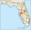
Florida's 15th congressional district is an electoral district for the U.S. Congress and is located in the northeastern suburbs of Tampa, including parts of Hillsborough, Pasco, and Polk counties. The district includes Plant City and Zephyrhills, as well as parts of Tampa city proper, Brandon, and Lakeland.
From 2003 to 2013, the prior 15th district contained most of Brevard County south of the city of Cocoa (including the Kennedy Space Center), all of Indian River County, most of Osceola County, and a very small portion of Polk County. The district took in the cities of Kissimmee, Melbourne, and Vero Beach, as well as Patrick Space Force Base. Boundaries were redrawn due to a lawsuit in 2015.[5] Much of this area is now the 8th district, while the current 15th takes in most of what was previously the 12th district.
From 2013 to 2017, the district included the northern parts of Hillsborough and Polk counties.[6][7] After court-ordered redistricting for the 2016 elections, it also included the southernmost parts of Lake County.
The district is currently represented by Republican Laurel Lee.
- ^ "Congressional Plan--SC14-1905 (Ordered by The Florida Supreme Court, 2-December-2015)" (PDF). Florida Senate Committee on Reapportionment. Retrieved January 11, 2017.
- ^ "Congressional Districts Relationship Files (State-based)". U.S. Census Bureau. Archived from the original on April 2, 2013.
- ^ a b "My Congressional District".
- ^ "2022 Cook PVI: District Map and List". Cook Political Report. Retrieved January 10, 2023.
- ^ Klas, Mary Ellen. "Florida Supreme Court approves congressional map drawn by challengers". Miami Herald. Retrieved July 17, 2017.
- ^ See whole Florida state map for 2013, with the 15th district in northern Hillsborough County and Polk County: h9047_35x42L.pdf Congressional Plan: H000C9047. Chapter No. 2012-2, Laws of Florida. www.flsenate.gov. February 16, 2012.
- ^ See 2013 borders of 15th district in the 2013 districts map: H000C9047_map_bb.pdf, for the Big Bend region of Florida. Congressional Plan: H000C9047. Chapter No. 2012-2, Laws of Florida. www.flsenate.gov. February 2012.

