Back Florida Panhandle BAR Florida Panhandle Danish Florida Panhandle German Florida Patotenilo Esperanto Mango de Florida Spanish پنهندل فلوریدا Persian Florida Panhandle Faeroese Panhandle de Floride French Panhandle fan Floarida Frisian Florida Panhandle Galician


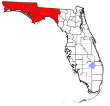
The Florida panhandle (also known as West Florida and Northwest Florida) is the northwestern part of the U.S. state of Florida. It is a salient roughly 200 miles (320 km) long, bordered by Alabama on the north and the west, Georgia on the north, and the Gulf of Mexico to the south. Its eastern boundary is arbitrarily defined. It is defined by its southern culture and rural geography relative to the rest of Florida, as well as closer cultural links to French-influenced Louisiana, Mississippi, and Alabama. Its major communities include Pensacola, Navarre, Destin, Panama City Beach, and Tallahassee.
As is the case with the other eight U.S. states that have panhandles, the geographic meaning of the term is inexact and elastic. References to the Florida panhandle always include the ten counties west of the Apalachicola River, a natural geographic boundary, which was the historic dividing line between the British colonies of West Florida and East Florida. These western counties also lie in the Central Time Zone (with the exception of Gulf County, which is divided between the Eastern and Central Time zones), while the rest of the state is in the Eastern Time Zone. References to the panhandle may also include some or all of eleven counties immediately east of the Apalachicola known as the Big Bend region, along the curve of Apalachee Bay.
Like the rest of North Florida,[1] including North Central Florida, the panhandle is more similar in culture and climate to the Deep South than the rest of the state, particularly than Central Florida and South Florida in the lower peninsula. The Florida panhandle is known for its conservative politics, religious adherence, and "piney woods".[2]
The largest city in the panhandle is Tallahassee, the state capital, population 196,169 (2020). However, the largest city west of the Appalachicola river is Pensacola, which has a population of 54,312 (2020) and also has the largest Metropolitan area in the entire panhandle with a population of 511,502 (2020). This metro area includes the second- and third-largest communities in the region, Pensacola and Navarre. The total population of the panhandle, as of the 2010 Census, was 1,407,925, just under 7.5% of Florida's total population as recorded in the same census. At roughly 70 persons per square mile, its population density is less than 20% of Florida's as a whole.[3]
- ^ "Deep South". The Free Dictionary. Retrieved May 25, 2018.
- ^ A Newsweek article in 1972, referring to then United States Senator Lawton Chiles, said "In 1958, he was elected to the state legislature from the ultraconservative piney-woods panhandle of Florida."
- ^ "Population estimates, July 1, 2019, (V2019)". Census.gov. Retrieved November 30, 2020.