Back Forcalquier Afrikaans Folcalquer AN فوركالكوي Arabic فوركالكوير ARZ Forcalquier BUG Forcalquer Catalan ФогӀкалькье CE Forcalquier CEB Forcalquier Czech Forcalquier Welsh
You can help expand this article with text translated from the corresponding article in French. (December 2008) Click [show] for important translation instructions.
|
Forcalquier | |
|---|---|
Subprefecture and commune | |
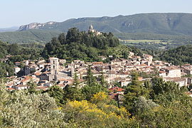
 A general view of Forcalquier, with the Luberon Massif in the background | |
| Coordinates: 43°57′36″N 5°46′50″E / 43.96°N 5.7806°E | |
| Country | France |
| Region | Provence-Alpes-Côte d'Azur |
| Department | Alpes-de-Haute-Provence |
| Arrondissement | Forcalquier |
| Canton | Forcalquier |
| Intercommunality | Pays de Forcalquier et Montagne de Lure |
| Government | |
| • Mayor (2020–2026) | David Gehant[1] |
| Area 1 | 42.76 km2 (16.51 sq mi) |
| Population (2021)[2] | 5,118 |
| • Density | 120/km2 (310/sq mi) |
| Time zone | UTC+01:00 (CET) |
| • Summer (DST) | UTC+02:00 (CEST) |
| INSEE/Postal code | 04088 /04300 |
| Elevation | 397–904 m (1,302–2,966 ft) (avg. 550 m or 1,800 ft) |
| 1 French Land Register data, which excludes lakes, ponds, glaciers > 1 km2 (0.386 sq mi or 247 acres) and river estuaries. | |
Forcalquier (French pronunciation: [fɔʁ.kal.kje]; Occitan: Forcauquier, pronounced [fuɾkɔwˈkje]) is a commune in the Alpes-de-Haute-Provence department in southeastern France.
Forcalquier is located between the Lure Mountain(fr) and Luberon mountain ranges, about 30 km (19 mi) south of Sisteron and 10 km (6.2 mi) west of the Durance river. During the Middle Ages it was the capital of Haute-Provence.
- ^ "Répertoire national des élus: les maires" (in French). data.gouv.fr, Plateforme ouverte des données publiques françaises. 13 September 2022.
- ^ "Populations légales 2021" (in French). The National Institute of Statistics and Economic Studies. 28 December 2023.


