Back Vrystaat Afrikaans الولاية الحرة (مقاطعة) Arabic Provincia del Estáu Llibre AST Fri-Steyt Azerbaijani Свабодная дзяржава (ПАР) BE-X-OLD Фрайстат Bulgarian Stad-Dieub Breton Estat Lliure (Sud-àfrica) Catalan Free State CEB Svobodný stát (provincie) Czech
This article includes a list of references, related reading, or external links, but its sources remain unclear because it lacks inline citations. (December 2023) |
Free State
| |
|---|---|
| Motto(s): Katleho ka kopano (Success through unity) | |
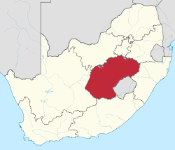
 Location of the Free State in South Africa | |
| Coordinates: 28°S 27°E / 28°S 27°E | |
| Country | South Africa |
| Orange Free State | 17 February 1854 |
| OFS Province | 31 May 1910 |
| Free State | 27 April 1994 |
| Capital | Bloemfontein |
| Districts | |
| Government | |
| • Type | Parliamentary system |
| • Premier | Maqueen Letsoha-Mathae (ANC) |
| • Legislature | Free State Provincial Legislature |
| Area [1]: 9 | |
• Total | 129,825 km2 (50,126 sq mi) |
| • Rank | 3rd in South Africa |
| Highest elevation | 3,291 m (10,797 ft) |
| Population (2022)[3] | |
• Total | 2,961,864 |
| • Rank | 8th in South Africa |
| • Density | 23/km2 (59/sq mi) |
| • Rank | 8th in South Africa |
| Population groups (2022) | |
| • Black | 88.9% |
| • White | 8.0% |
| • Coloured | 2.6% |
| • Indian or Asian | 0.4% |
| • Other | 0.1% |
| Languages (2022) | |
| • Sotho | 72.3% |
| • Afrikaans | 10.3% |
| • Xhosa | 5.5% |
| • Tswana | 5.3% |
| • English | 1.5% |
| Time zone | UTC+2 (SAST) |
| ISO 3166 code | ZA-FS |
| GDP | US$20.0 billion[4] |
| HDI (2019) | 0.708[5] high · 4th of 9 |
| Website | www |
| Zulu | iFuleyisitata |
|---|---|
| Xhosa | iFreyistata |
| Afrikaans | Vrystaat |
| Sesotho | Freistata |
| Setswana | Foreistata |
The Free State (Sotho: Freistata; Afrikaans: Vrystaat [ˈfrɛistɑːt]; Xhosa: iFreyistata; Tswana: Foreistata; Zulu: iFuleyisitata), formerly known as the Orange Free State, is a province of South Africa. Its capital is Bloemfontein, which is also South Africa's judicial capital. Its historical origins lie in the Boer republic called the Orange Free State and later the Orange Free State Province.
- ^ Census 2011: Census in brief (PDF). Pretoria: Statistics South Africa. 2012. ISBN 9780621413885. Archived (PDF) from the original on 13 May 2015.
- ^ "Taking the measure of Namahadi Peak" (PDF). Archived from the original (PDF) on 9 July 2007. Retrieved 24 September 2009.
- ^ a b c "Statistical Release - Census 2022" (PDF). statssa.gov.za. Retrieved 22 August 2024.
- ^ "Provincial gross domestic product:experimental estimates, 2013–2022" (PDF), www.statssa.gov.za
- ^ "Sub-national HDI – Area Database – Global Data Lab". hdi.globaldatalab.org. Retrieved 13 September 2018.
