Back Gash-Barka AST Гаш-Барка Bulgarian Gash-Barka Breton Regió de Gash-Barka Catalan Gash-Barka Region CEB Gash-Barka Danish Gash-Barka German Gaŝ-Barka (Regiono) Esperanto Región de Gash-Barka Spanish منطقه گاش-بارکا Persian
A request that this article title be changed to Gash-Barka region is under discussion. Please do not move this article until the discussion is closed. |
Gash-Barka Region
| |
|---|---|
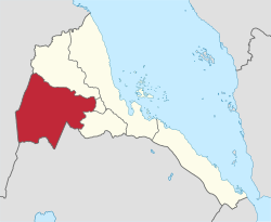
 Gash-Barka Region in Eritrea | |
| Coordinates: 15°15′N 37°30′E / 15.250°N 37.500°E | |
| Country | |
| Capital | Barentu |
| Government | |
| • Administrator | Musa Raba |
| Area | |
• Total | 33,200 km2 (12,800 sq mi) |
| Population | |
• Total | 1,103,742 [citation needed] |
| ISO 3166 code | ER-GB |
| HDI (2022) | 0.370[1] low · 6th |
Gash-Barka (Tigrinya: ጋሽ-ባርካ, Arabic: إقليم قاش بركة) is an administrative region of Eritrea. It is situated in the south-west of the country, bordering the Anseba region to the north, and the Maekel (Central) and Debub (Southern) regions to the east; the country of Sudan lies to the west and Ethiopia to the south.
The capital of Gash-Barka is Barentu. Other towns include Agordat (the former capital), Molki, Sebderat and Teseney. As of 2005, the region had a population of 708,800 compared to a population of 625,100 in 2001.[citation needed] The net growth rate was 11.81 per cent. The total area of the province was 33,200 km2 and the density was 21.35 persons per km2., making up roughly one-third of Eritrea. The region is dubbed as the "breadbasket" of the country as it is rich in agriculture.[citation needed] The region is also rich in marble, and other important minerals, including gold. In Ougaro, there are some old mineshafts and machinery from the days when the Italians mined gold there.[citation needed]
- ^ "Sub-national HDI - Area Database - Global Data Lab". hdi.globaldatalab.org. Retrieved 2018-09-13.