Back نهر جيديز ARZ Gediz çayı Azerbaijani Гедыз Byelorussian Гедиз (река) Bulgarian Gediz Catalan Gediz Nehri CEB Gediz Czech Gediz German Έρμος ποταμός Greek Gediz Esperanto
| Gediz River | |
|---|---|
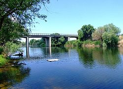
 Gediz River in its downstream section crossing İzmir Province | |
 | |
| Location | |
| Country | Turkey |
| Physical characteristics | |
| Source | Mount Murat |
| • location | Kütahya Province |
| Mouth | Gediz River Delta |
• location | Foça, İzmir Province |
• coordinates | 38°35′18″N 26°48′57″E / 38.58833°N 26.81583°E |
| Length | 401 km (249 mi) |
The Gediz River (Turkish: Gediz Nehri, Turkish pronunciation: [ˈɡediz]), anciently known as the Hermus River (Ancient Greek: Έρμος), is the second-longest river in Anatolia flowing into the Aegean Sea. From its source of Mount Murat in Kütahya Province, it flows generally west for 401 km (249 mi) to the Gediz River Delta in the Gulf of İzmir.