Back جغرافيا إسرائيل Arabic Xeografía d'Israel AST İsrail coğrafiyası Azerbaijani География на Израел Bulgarian ইসরায়েলের ভূগোল Bengali/Bangla Heograpiya sa Israel CEB Geografie Izraele Czech Israels geografi Danish Geographie Israels German Γεωγραφία του Ισραήλ Greek
 | |
| Continent | Asia |
|---|---|
| Region | Levant |
| Coordinates | 31°N 35°E / 31°N 35°E |
| Area | Ranked 150th |
| • Total | 20,770[1][2] km2 (8,020 sq mi) |
| • Land | 97.88% |
| • Water | 2.12% |
| Coastline | 273[1] km (170 mi) |
| Borders | |
| Highest point | Mount Meron |
| Lowest point | Dead Sea |
| Longest river | Jordan River |
| Largest lake | Sea of Galilee |
| Climate | Mediterranean |
| Natural resources | Offshore gas fields, Dead Sea minerals (potash, magnesium) |
| Exclusive economic zone | 26,352 km2 (10,175 sq mi) |
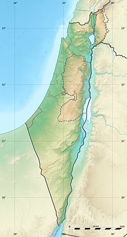
The geography of Israel is very diverse, with desert conditions in the south, and snow-capped mountains in the north. Israel is located at the eastern end of the Mediterranean Sea in West Asia.[1] It is bounded to the north by Lebanon, the northeast by Syria, the east by Jordan and the West Bank, and to the southwest by Egypt.[1] To the west of Israel is the Mediterranean Sea, which makes up the majority of Israel's 273 km (170 mi) coastline,[3] and the Gaza Strip. Israel has a small coastline on the Red Sea in the south.
Israel's area is approximately 20,770 km2 (8,019 sq mi), which includes 445 km2 (172 sq mi) of inland water.[1][2][3] Israel stretches 424 km (263 mi) from north to south, and its width ranges from 114 km (71 mi) at its widest point to 10 km (6.2 mi) at its narrowest point.[3] It has an Exclusive Economic Zone of 26,352 km2 (10,175 sq mi).
The Israeli-occupied territories include the West Bank, 5,879 km2 (2,270 sq mi), East Jerusalem, 70 km2 (27 sq mi) and the Golan Heights, 1,150 km2 (444 sq mi).[2] Geographical features in these territories will be noted as such. Of these areas, Israel has annexed East Jerusalem and the Golan Heights, an act not recognized by the international community.
Southern Israel is dominated by the Negev desert, covering some 16,000 square kilometres (6,178 sq mi), more than half of the country's total land area. The north of the Negev contains the Judean Desert, which, at its border with Jordan, contains the Dead Sea which, at −417 m (−1,368 ft) is the lowest point on Earth. The inland area of central Israel is dominated by the Judean Hills of the West Bank, whilst the central and northern coastline consists of the flat and fertile Israeli coastal plain. Inland, the northern region contains the Mount Carmel mountain range, which is followed inland by the fertile Jezreel Valley, and then the hilly Galilee region. The Sea of Galilee is located beyond this region and is bordered to the east by the Golan Heights, a plateau bordered to the north by the Israeli-occupied part of the Mount Hermon massif, which includes the highest point under Israel's control, a peak of 2,224 meters (7,297 ft). The highest point in territory internationally recognized as Israeli is Mount Meron at 1,208 meters (3,963 ft).[1]
- ^ a b c d e f g h i j k l m "Israel". CIA World Factbook. Retrieved 8 April 2008.
- ^ a b c Federal Research Division (2004). Israel A Country Study (Paperback ed.). Kessinger Publishing, LLC. p. 8. ISBN 978-1-4191-2689-5.
- ^ a b c "Israel – Geography". U.S. Library of Congress. Retrieved 8 April 2008.