Back 13.º distrito congresional de Georgia Spanish حوزه انتخابیه سیزدهم جورجیا Persian Treizième district congressionnel de Géorgie French
33°38′56.12″N 84°43′45.51″W / 33.6489222°N 84.7293083°W
| Georgia's 13th congressional district | |
|---|---|
Interactive map of district boundaries | |
| Representative | |
| Distribution |
|
| Population (2023) | 773,905[2] |
| Median household income | $76,312[2] |
| Ethnicity |
|
| Cook PVI | D+28[3] |
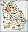
Georgia's 13th congressional district is a congressional district in the U.S. state of Georgia. The district is currently represented by Democrat David Scott, though the district's boundaries have been redrawn following the 2010 census, which granted an additional congressional seat to Georgia.[4] The first election using the new district boundaries (listed below) were the 2012 congressional elections.
The district is located in the southern and western portions of the Atlanta metropolitan area and includes the cities of Austell, Jonesboro, Mableton, Douglasville, Stockbridge, and Union City, as well as the southern fourth of Atlanta itself.[5][6]
- ^ "Congressional Districts Relationship Files (State-based) - Geography - U.S. Census Bureau". Archived from the original on April 2, 2013.
- ^ a b Center for New Media & Promotion (CNMP), US Census Bureau. "My Congressional District". www.census.gov.
- ^ "2022 Cook PVI: District Map and List". Cook Political Report. Retrieved January 10, 2023.
- ^ Justice Department approves Georgia's political maps Archived January 7, 2012, at the Wayback Machine. Atlanta Journal-Constitution. Last accessed December 27, 2011
- ^ 2012 Congressional maps, Georgia Legislature. Last accessed January 1, 2012
- ^ 2012 Congressional maps - Metro Atlanta, Georgia Legislature. Last accessed January 1, 2012


