This article needs additional citations for verification. (January 2021) |
| Coordinates: 31°43′12″N 76°01′30″E / 31.720°N 76.025°E | |
| Country | |
| State | Himachal Pradesh |
| District | Una |
| Elevation | 470 m (1,540 ft) |
| Population | |
| • Total | 5,000 |
| Languages | |
| • Official | English|Hindi |
| Time zone | UTC+5:30 (IST) |
| PIN | 177212 |
| Telephone code | 01976 |
| Vehicle registration | HP-19AA, HP-19AB, HP-72 (District RTO) |
| Nearest city | Hoshiarpur, Talwara, Una, Chintpurni |
| Lok Sabha constituency | Hamirpur |
| Climate | Hot and humid. (Köppen) |
| Avg. summer temperature | 31 °C (88 °F) |
| Avg. winter temperature | 10 °C (50 °F) |
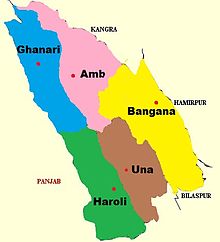
Ghanari is the headquarter of Tehsil Ghanari in Una district of Himachal Pradesh, India. It comes under Gagret vidhan sabha constituency and shares border with Punjab and lies on the bank of the seasonal Swan River. It is situated in plains of District Una.
Origin of name Ghanari lies in two Sanskrit words Ghan(घन) which means clouds and ari(अरी) which means enemy. It is said that a lot of times in past it used to rain in all surrounding places but not in Ghanari. Thats why this place was named Ghanari(Ghan + Ari).
Ghanari is 7 kilometres (4.3 mi) from both Gagret and Daulatpur, 32 kilometres (20 mi) from Hoshiarpur, 28 kilometres (17 mi) from Talwara, and 42 kilometres (26 mi) from district headquarters at Una, Himachal Pradesh.

