Back Gilarivier Afrikaans نهر غيلا Arabic نهر جيلا ARZ Хіла (прыток Каларада) Byelorussian Хила Bulgarian Riu Gila Catalan Gila River (suba sa Tinipong Bansa, Yuma County) CEB Gila Czech Хила (Колорадо юппи) CV Gila River Danish
| Gila River | |
|---|---|
 The river in the Gila Box Canyon in eastern Arizona | |
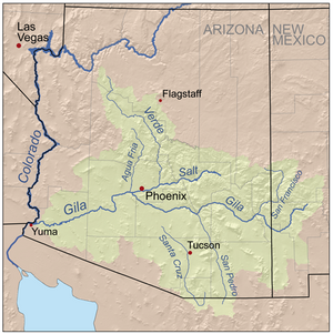
 Map of the Gila River watershed | |
| Location | |
| Country | United States |
| State | Arizona |
| State | New Mexico |
| Physical characteristics | |
| Source | Confluence of East and West Forks |
| • location | Grant County, New Mexico |
| • coordinates | 33°10′47″N 108°12′22″W / 33.17972°N 108.20611°W[1] |
| • elevation | 5,551 ft (1,692 m) |
| Mouth | Colorado River |
• location | Yuma, Arizona |
• coordinates | 32°43′11″N 114°33′19″W / 32.71972°N 114.55528°W[1] |
• elevation | 118 ft (36 m) |
| Length | 649 mi (1,044 km)[2] |
| Basin size | 58,200 sq mi (151,000 km2)[2] |
| Discharge | |
| • location | Dome, AZ; 12 mi (19 km) from the mouth[3] |
| • average | 247 cu ft/s (7.0 m3/s)[3] |
| • minimum | 0 cu ft/s (0 m3/s) |
| • maximum | 200,000 cu ft/s (5,700 m3/s) |
| Basin features | |
| Tributaries | |
| • left | San Simon River, San Pedro River, Santa Cruz River |
| • right | San Francisco River, Salt River, Agua Fria River, Hassayampa River |
 | |
The Gila River (/ˈhiːlə/; O'odham [Pima]: Keli Akimel or simply Akimel, Quechan: Haa Siʼil, Maricopa language: Xiil[4]) is a 649-mile-long (1,044 km)[2] tributary of the Colorado River flowing through New Mexico and Arizona in the United States. The river drains an arid watershed of nearly 60,000 square miles (160,000 km2) that lies mostly within the U.S., but also extends into northern Sonora, Mexico.
Indigenous peoples have lived along the river for at least 2,000 years, establishing complex agricultural societies before European exploration of the region began in the 16th century. European Americans did not permanently settle the Gila River watershed until the mid-19th century.
During the 20th century, development in the Gila River watershed prompted the construction of large diversion and flood control structures on the river and its tributaries, and consequently the Gila contributes only a small fraction of its historic flow to the Colorado.[5] The historic natural discharge of the river was around 1,900 cubic feet per second (54 m3/s), but has declined to only 247 cubic feet per second (7.0 m3/s). The engineering projects transformed much of the river valley and its surroundings from arid desert into irrigated land, and supply water to more than five million people in the Phoenix and Tucson metropolitan areas who live in the watershed.
- ^ a b "Gila River". Geographic Names Information System. United States Geological Survey, United States Department of the Interior. 1980-02-08. Retrieved 2012-03-16.
- ^ a b c Kammerer, J.C. "Largest Rivers in the United States". U.S. Geological Survey. Retrieved 2012-03-16.
- ^ a b "USGS Gage #09520500 on the Gila River near Dome, AZ" (PDF). National Water Information System. U.S. Geological Survey. 1903–2011. Retrieved 2012-03-16.
- ^ Antone, Caroline. Piipayk m'iim. Salt River: Oʼodham Piipaash Language Program, 2000.
- ^ "The Gila is mostly bone dry in its lower reaches" (Jonathan Waterman, "American Nile: Saving the Colorado", National Geographic).