Back Glen Coe Afrikaans Gleann Comhann Breton Glen Coe Catalan Glen Coe CEB Glen Coe Czech Glen Coe German Glen Coe Spanish Glen Coe Estonian Glen Coe Basque گلن کو Persian
| Glen Coe National Nature Reserve | |
|---|---|
IUCN category IV (habitat/species management area)[1] | |
 Panoramic view westwards along the glen towards the Three Sisters of Bidean nam Bian, with Aonach Eagach on the right | |
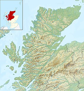
| Location | Highland, Scotland |
| Coordinates | 56°40′04″N 04°59′12″W / 56.66778°N 4.98667°W |
| Area | 56.3 km2 (21.7 sq mi)[2] |
| Designation | NatureScot |
| Established | 2017 |
| Owner | National Trust for Scotland |
Glen Coe (Scottish Gaelic: Gleann Comhann[3] pronounced [klan̪ˠˈkʰo.ən̪ˠ]) is a glen of volcanic origins,[4] in the Highlands of Scotland. It lies in the north of the county of Argyll, close to the border with the historic province of Lochaber, within the modern council area of Highland. Glen Coe is regarded as the home of Scottish mountaineering[5] and is popular with hillwalkers and climbers.
A 2010 review by Scottish Natural Heritage into the special qualities of Scotland's National scenic areas listed the "soaring, dramatic splendour of Glen Coe", and "the suddenness of the transition between high mountain pass and the lightly wooded strath" as being of note. The review also described the journey through the glen on the main A82 road as "one of the classic Highland journeys".[4] The main settlement is the village of Glencoe located at the foot of the glen.[6]
On 13 February 1692, in the aftermath of the Jacobite uprising of 1689, an incident known as the Massacre of Glencoe took place in the glen. Thirty-eight men from Clan MacDonald of Glencoe were killed by government forces who were billeted with them on the grounds that they had not been prompt in pledging allegiance to the new monarchs, William and Mary.[7]
The Glen is named after the River Coe which runs through it. The name of the river may predate the Gaelic language, as its meaning is not known. It is possible that the name stems from an individual personal name, Comhan (genitive Comhain).[8]
- ^ Cite error: The named reference
planetwas invoked but never defined (see the help page). - ^ "Site Details for Glencoe NNR". NatureScot. Retrieved 8 September 2020.
- ^ "Glencoe". Ainmean-Àite na h-Alba. Retrieved 17 January 2022.
- ^ a b "The special qualities of the National Scenic Areas. Scottish Natural Heritage Commissioned Report No.374'" (PDF). Scottish Natural Heritage. 2010. Retrieved 14 February 2018.
- ^ "Glencoe National Nature Reserve". Scottish Natural Heritage. 21 August 2017. Archived from the original on 31 January 2018. Retrieved 14 February 2018.
- ^ Ordnance Survey Landranger 1:50000, Sheet 41
- ^ "The Massacre of Glen Coe". BBC. 14 September 2014. Retrieved 14 February 2018.
- ^ Sabhal Mòr Ostaig, An t-Eilean Sgitheanach, 11 Sep 2007
