Back Gloucestershire Afrikaans Gloucestershire AN Gleawcesterscīr ANG غلوسترشير Arabic Gloucestershire AST Gloucestershire BAN Gloucestershire BAR Глостэршыр Byelorussian Глостэршыр BE-X-OLD Глостършър Bulgarian
Gloucestershire | |
|---|---|
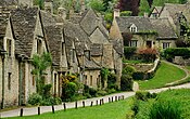
Gloucester Cathedral, the village of Bibury in the Cotswolds, and the Second Severn Crossing in South Gloucestershire | |
 | |
| Coordinates: 51°50′N 2°10′W / 51.833°N 2.167°W | |
| Sovereign state | United Kingdom |
| Constituent country | England |
| Region | South West |
| Established | Ancient |
| Time zone | UTC+0 (GMT) |
| • Summer (DST) | UTC+1 (BST) |
| UK Parliament | List of MPs |
| Police | Gloucestershire Constabulary |
| Ceremonial county | |
| Lord Lieutenant | Edward Gillespie |
| High Sheriff | H C W Robinson (2023-2024) |
| Area | 3,150 km2 (1,220 sq mi) |
| • Rank | 16th of 48 |
| Population (2022)[1] | 947,174 |
| • Rank | 24th of 48 |
| Density | 301/km2 (780/sq mi) |
| Ethnicity | 91.6% White British |
| Non-metropolitan county | |
| County council | Gloucestershire County Council |
| Control | Conservative |
| Admin HQ | Gloucester |
| Area | 2,653 km2 (1,024 sq mi) |
| • Rank | 10th of 21 |
| Population (2022)[2] | 652,409 |
| • Rank | 18th of 21 |
| Density | 246/km2 (640/sq mi) |
| ISO 3166-2 | GB-GLS |
| GSS code | E10000013 |
| ITL | UKK13 |
| Website | gloucestershire |
| Unitary authorities | |
| Councils | South Gloucestershire Council |
| Districts | |
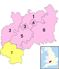
 Districts of Gloucestershire Unitary County council area | |
| Districts | |
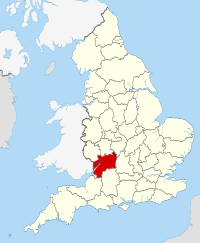
Gloucestershire (/ˈɡlɒstərʃər/ GLOST-ər-shər, /-ʃɪər/ -sheer; abbreviated Glos.)[3] is a ceremonial county in South West England. It is bordered by Herefordshire to the north-west, Worcestershire to the north, Warwickshire to the north-east, Oxfordshire to the east, Wiltshire to the south, Bristol and Somerset to the south-west, and the Welsh county of Monmouthshire to the west. The city of Gloucester is the largest settlement and the county town.
The county is predominantly rural, with an area of 3,150 square kilometres (1,220 sq mi) and a population of 916,212. After Gloucester (118,555) the largest distinct settlements are Cheltenham (115,940), Stroud (26,080), and Yate (28,350).[4] In the south of the county, the areas around Filton and Kingswood are densely populated and part of Bristol built-up area. For local government purposes Gloucestershire comprises a non-metropolitan county, with six districts, and the unitary authority area of South Gloucestershire. South Gloucestershire Council is a member of the West of England Combined Authority.
Gloucestershire is bisected by the river River Severn, which enters the county near Tewkesbury and forms a wide valley down its centre before broadening into a large tidal estuary. The hills to the east form the majority of the Cotswolds AONB, and the uplands to the west are part of the Forest of Dean and the Wye Valley AONB, which stretches into Wales.
Gloucestershire was likely established in the tenth century, and expanded to approximately its current borders in the eleventh. The county was relatively settled during the late Middle Ages, and contained several wealthy monasteries such as Tewkesbury, Gloucester, Hailes, and Cirencester; the Forest of Dean was also a major iron-producing region in this period. The city of Bristol became an independent county in 1373, by which point it was the third-largest city in England. Gloucestershire was not heavily industrialised during the Industrial Revolution, but the Port of Gloucester was expanded with new docks and the small Forest of Dean coalfield was exploited.
- ^ "Mid-2022 population estimates by Lieutenancy areas (as at 1997) for England and Wales". Office for National Statistics. 24 June 2024. Retrieved 26 June 2024.
- ^ "Mid-Year Population Estimates, UK, June 2022". Office for National Statistics. 26 March 2024. Retrieved 3 May 2024.
- ^ "Abbreviations". Oxford English Dictionary. Archived from the original on 19 June 2020. Retrieved 28 June 2020.
- ^ "Towns and cities, characteristics of built-up areas, England and Wales: Census 2021". Office for National Statistics. 2 August 2023. Retrieved 6 December 2023.


