Back Goirle AN خورلا Arabic Goirle Catalan Gemeente Goirle CEB Goirle Danish Goirle German Goirle Esperanto Goirle Spanish Goirle Basque خویرله Persian
Goirle | |
|---|---|
 Goirle town centre | |
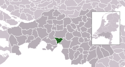
 Location in North Brabant | |
| Coordinates: 51°31′N 5°4′E / 51.517°N 5.067°E | |
| Country | Netherlands |
| Province | North Brabant |
| Government | |
| • Body | Municipal council |
| • Mayor | Mark van Stappershoef (CDA) |
| Area | |
| • Total | 43.38 km2 (16.75 sq mi) |
| • Land | 42.99 km2 (16.60 sq mi) |
| • Water | 0.39 km2 (0.15 sq mi) |
| Elevation | 16 m (52 ft) |
| Population (January 2021)[4] | |
| • Total | 23,952 |
| • Density | 557/km2 (1,440/sq mi) |
| Demonym | Goirlenaar |
| Time zone | UTC+1 (CET) |
| • Summer (DST) | UTC+2 (CEST) |
| Postcode | 5050–5053, 5133 |
| Area code | 013 |
| Website | www |
Goirle (pronounced [ˈɣoːrlə] ) is a municipality and town in the southern Netherlands, in the province of North Brabant. Part of the suburban area of the city of Tilburg, it shares with it its phone area code and public transport system.
The municipality also includes the villages of Breehees and Riel.
- ^ "Mevr. M.G. Rijsdorp" (in Dutch). Gemeente Goirle. Archived from the original on 22 April 2014. Retrieved 21 April 2014.
- ^ "Kerncijfers wijken en buurten 2020" [Key figures for neighbourhoods 2020]. StatLine (in Dutch). CBS. 24 July 2020. Retrieved 19 September 2020.
- ^ "Postcodetool for 5051LT". Actueel Hoogtebestand Nederland (in Dutch). Het Waterschapshuis. Archived from the original on 21 September 2013. Retrieved 21 April 2014.
- ^ "Bevolkingsontwikkeling; regio per maand" [Population growth; regions per month]. CBS Statline (in Dutch). CBS. 1 January 2021. Retrieved 2 January 2022.

