Back Groot Skeidingsgebergte Afrikaans غريت ديفايدينغ Arabic جريت ديفايدينج ARZ Gran Cordal Divisoriu AST Böyük Suayırıcı sıra dağları Azerbaijani Ҙур Һыу айырғыс һырт Bashkir Вялікі Водападзельны хрыбет Byelorussian Вялікі Водападзельны хрыбет BE-X-OLD Голяма вододелна планина Bulgarian ग्रेट डिवाइडिंग रेंज Bihari
This article has multiple issues. Please help improve it or discuss these issues on the talk page. (Learn how and when to remove these messages)
|
| Great Dividing Range | |
|---|---|
| |
 Great Dividing Range | |
| Highest point | |
| Peak | Mount Kosciuszko, Snowy Mountains |
| Elevation | 2,228 m (7,310 ft)[1] |
| Coordinates | 36°27′21″S 148°15′49″E / 36.45583°S 148.26361°E |
| Dimensions | |
| Length | 3,500 km (2,200 mi) North–South |
| Geography | |
| Country | Australia[2] |
| States/Districts | |
| Range coordinates | 25°S 147°E / 25°S 147°E |
| Geology | |
| Rock age | Carboniferous |
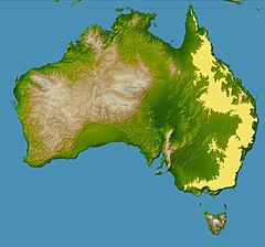
The Great Dividing Range, also known as the East Australian Cordillera or the Eastern Highlands, is a cordillera system in eastern Australia consisting of an expansive collection of mountain ranges, plateaus and rolling hills. It runs roughly parallel to the east coast of Australia and forms the fifth-longest land-based mountain chain in the world, and the longest entirely within a single country. It is mainland Australia's most substantial topographic feature and serves as the definitive watershed for the river systems in eastern Australia, hence the name.
The Great Dividing Range stretches more than 3,500 kilometres (2,175 mi) from Dauan Island in the Torres Strait off the northern tip of Cape York Peninsula, running the entire length of the eastern coastline through Queensland and New South Wales, then turning west across Victoria before finally fading into the Wimmera plains as rolling hills west of the Grampians region. The width of the Range varies from about 160 km (100 mi) to over 300 km (190 mi).[3] The Greater Blue Mountains Area, Gondwana Rainforests and Wet Tropics of Queensland World Heritage Areas are located in the Range. The highest place in Australia, the 2,228 m (7,310 ft) Mount Kosciuszko, resides in the Snowy Mountains portion of southern Great Dividing Range.
- ^ Cite error: The named reference
KNPwas invoked but never defined (see the help page). - ^ Cite error: The named reference
AustraliDotGovDotAuwas invoked but never defined (see the help page). - ^ Shaw, John H., Collins Australian Encyclopedia, William Collins Pty Ltd., Sydney, 1984, ISBN 0-00-217315-8
